You know how people say that we only use one-tenth of our brains? That if we could just harness the full power of our neurons, we’d be mental superheroes?
Well, that’s probably not true. But it’s an apt metaphor for something that is true about Chicago’s public transit system.
Let’s start with the basics. When you think about Chicago trains, you probably think of a network like this:
That’s the eight lines that make up the L—and it’s the map you’d see at any CTA station.
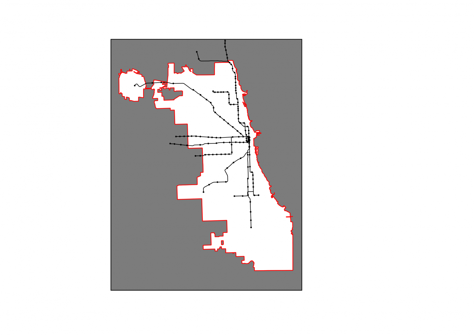
But it’s not actually a complete map of the city’s passenger rail network. In fact, it’s missing more than half of it. The real map of all the trains you can take around the city looks like this:

There are actually 20 rail lines that serve Chicago: eight CTA lines, 11 Metra lines, and the South Shore Line, a commuter railroad that runs into northwest Indiana. But accidents of history have split these lines among three different public agencies—none of which, traditionally, have bothered to tell you about the others on their maps or signage. That means that when you look at a map on a CTA train car, there are actually more than 70 rail stations in the city of Chicago that exist in real life—I promise—but mysteriously do not exist on that map.
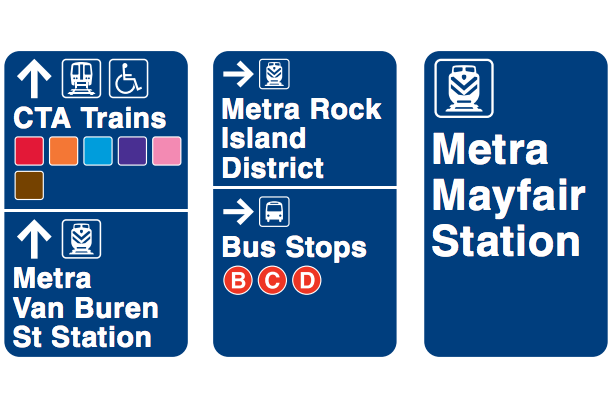
Fortunately, the Regional Transportation Authority (the umbrella organization for the CTA, Metra, and the suburban Pace bus service) has announced that it’s taking some small steps to fix this. The RTA has created maps that show travelers all of their transit options, regardless of the agency that provides them, and is placing them at 14 more locations around Chicagoland, after beginning with just four in the last few years. (The RTA isn’t totally alone in this: Over the same period, the CTA has added symbols to their maps on L cars telling riders where they can transfer to Metra trains—but it has not announced plans to tell riders where those trains actually go. And while some of the more detailed maps at CTA bus and L stations include Metra lines, they’re so faint that most riders won’t see them unless they know to look.)
These steps are great news, because when people don’t know what their options are, they can’t use them. Someone going from Rogers Park to Logan Square using only the CTA, for example, could spend well over an hour taking the Red Line to the Brown Line to the Armitage bus—or they could cut their travel time almost in half by taking Metra’s Union Pacific-North Line to the Clybourn station near Armitage instead (though to get to the heart of that large neighborhood, you'd still have to climb onto the Armitage bus). Since most people aren’t willing to spend over an hour traveling within the city if they don’t have to, that’s likely the difference between that person using transit and staying at home—or getting in their car, adding to traffic and carbon emissions.
Now, to be clear, there are a lot of other things that need to change for Chicago to use all of its transit brain power, so to speak. Metra trains come no more than once an hour at most times of day, which makes it hard to rely on them for many trips. Just as importantly, Chicago’s transit agencies don’t allow people to transfer seamlessly between their services. That means that while switching from a CTA bus to a CTA train costs just 25 cents, switching from the CTA to a Metra train will set you back a couple dollars each way.
But the upside to making these changes is almost unthinkably huge. Chicago has struggled to pay for the multi-billion-dollar costs of even modest expansions to its L system, like the five stations planned for the Red Line extension to 130th Street. Meanwhile, on the South Side alone, Metra is operating over 40 stations on several lines—including one that travels in nearly the same place as the Red Line extension—that many people simply never use, either because of scheduling and transfer issues, or because they don’t even know that it’s there.
Just across the Great Lakes, Toronto faces a similar issue, and it's doing something about it. Their transit agencies have announced a plan to have GO Trains—their equivalent of Metra—eventually run every 15 minutes during the day, allowing people to rely on them for all kinds of trips, and not just commuting.
Making all of Chicago's rail lines clear and viable options for public transit would be equivalent to spending tens of billions of dollars to expand the L, all without building one new station or laying a single mile of new track. It would bring dramatically better transit access to hundreds of thousands of people, including in some of the city’s most disinvested communities. In many ways, it would be perhaps the most revolutionary change to the city’s transportation system since the construction of grade-separated highways—but one that would help to knit our communities together, rather than tear them apart.
That’s heady stuff, especially given that we’re starting with just fourteen new maps. But acknowledging that these resources exist is the first step towards actually using them.