Two years ago, Mayor Rahm Emanuel announced the city would finally separate bike and pedestrian paths along the entire length of the Chicago Lakefront Trail. Since then, he’s noticed a common reaction.
People approach him at events and on his train commute to share a horror story of a collision or close call along the old path. After a groundbreaking at the newly renovated Theater on the Lake, for instance, a runner struck by a bike told him she’d had three surgeries.
When 100,000 people share a narrow slab of pavement on an average summer weekend day, there are bound to be issues. “The old path was old,” Emanuel says. “It’s the third most used park in America, and we hadn’t made the investment to keep pace with the way residents were using it.”
Now, save some landscape restoration that’ll happen in the spring, the project’s done. City officials planning the route solicited feedback from trail users in a survey and also worked closely with advocacy groups like the Chicago Area Runners Association and the Active Transportation Alliance. Besides (one hopes) fewer accidents, here’s what you’ll see along the way.
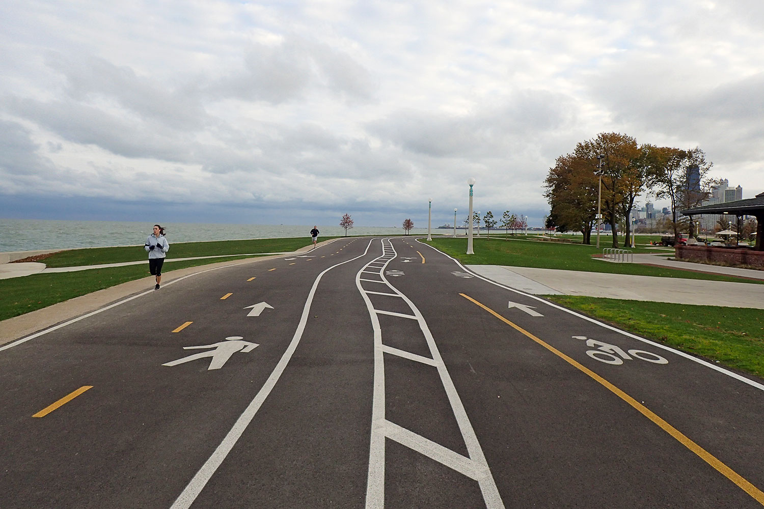
1. There’s more breathing room between cyclists and pedestrians
The whole point of the project was to get people going at different speeds traveling different routes. Ideally, that meant a 12-foot-wide bike trail and a 14-foot pedestrian path, with a bit of a buffer between them. “We tried to achieve that in every area we could,” says Heather Gleason, the Park District’s Director of Planning and Construction.
If you’re on two feet, “for the most part, the trail pulls you close to the lake at all times,” says Park District General Superintendent Michael Kelly. Cyclists, meanwhile, typically pedal closer to Lake Shore Drive.
The few exceptions occurred due to factors like wildlife habitat preservation, disability access, and space constraints. In some particularly tight stretches — for instance, Oak Street to Ohio Street — four lines of traffic essentially move side by side. And between Foster and Montrose Avenues, the path is flipped, with cyclists riding lakeside east of Cricket Hill and walkers and runners sticking closer to the road.
2. … and fewer risky encounters with motor vehicles.
A huge goal, Gleason says, was to minimize contact between people and cars. Both sections of the path now route through an underpass at Montrose Avenue instead of battling beach-bound automobiles. That intersection was previously so congested it required traffic control personnel on summer weekends.
Cyclists also avoid Foster, Lawrence, and Wilson Avenues, though the pedestrian path still crosses them. At 63rd Street beach — another crowded spot — the Park District chose to swing the cycling path farther away from the parking lot to put more distance between them and yet more cars full of beachgoers, Gleason said.
A related project — the Navy Pier Flyover — also partially opened in December, allowing both cyclists and pedestrians to avoid crossing Grand and Illinois Avenues downtown.
3. Signage has moved groundward.
In years past, most trail directions were posted on freestanding placards, many of which also contained (helpful but often disregarded) lists of trail-etiquette rules.
In response to trail user surveys and to avoid “sign pollution” — “I want as many signs as is necessary, but I want as few signs as we can pull off,” Kelly says — the paths are now mostly marked with paint on the pavement. Look down, and you’ll see either a cyclist or a walking figure depicted at regular intervals, along with an arrow indicating the proper direction.
It’s rare, but in a few spots, the two paths cross — for instance, just north of Foster Avenue and just south of Montrose Avenue. There, you’ll find freestanding signs giving travelers a heads-up.
At some point in the future, there might be more negative signage, something CARA and Active Trans leaders say they support (say, a “no pedestrians” notice by the cycling path, or a bike with a line through it on the running path). But Gleason and Kelly said they’d like to see how people actually use the path first.
4. The mileage has been recalibrated.
Another thing you’ll spot on above-ground posts: new mile markers. CARA used the Jones Counter — a tool mounted on a bike wheel and used to certify road-race distances — to recalculate the distances.
They’re measured down the center of the path, meaning they’re largely accurate in both directions, says CARA’s executive director Greg Hipp. The pedestrian path now measures 18.5 miles and the bike path 18.1 miles, with markers every half-mile.
5. The enforcement policy hasn’t changed — but there’s good reason to follow the rules.
There still aren’t trail patrols out to write tickets for those who stray from their assigned routes. But the more people stick to the plan, the greater the reduction in conflicts, says Kyle Whitehead, managing director of public affairs for Active Trans.
“There’s never going to be a hundred percent compliance; there’s always going to be people who are traveling on a wrong path,” he says. “But the hope and the experience so far has been that it’s much better and much safer experience than it was before the project started.”
As spring and summer crowds return to the trail, the Park District will monitor the flow, Gleason says. Regular users already have a few quibbles. The Montrose change adds extra distance to many cyclists’ commutes, Whitehead says. Runners lost some of their soft-surface paths and even gained a few new hard-on-the-legs concrete sections, including near Belmont Harbor and McCormick Place, Hipp points out.
The updates “require a change of habit, and maybe using a new trail that you feel is less ideal,” Hipp says. “But it’s really up to all of us that use the trail to make it work.” Those with questions or complaints can contact either CARA or Active Trans, who’ve pledged to work with the city on fine-tuning and updating, or touch base with the Park District through the website.