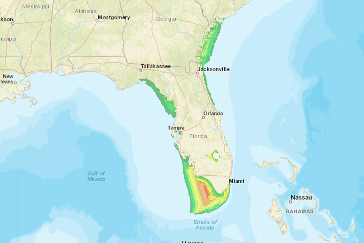
Hurricane Irma—after virtually destroying the islands of Barbuda and St. Martin—is bearing down on Florida, with Category 4 or higher winds that could extend across the entire state. But the wind isn't the only danger. A storm surge of 5 to 10 feet around Miami and 6 to 12 feet on the Gulf Coast side of South Florida is expected. As Jim Carlton details for The Wall Street Journal, it could destroy coastal buildings, and also poses a risk for Lake Okeechobee in Central Florida, where a storm surge caused by a 1928 hurricane killed 2,500 people living near its banks. Generally speaking, storm surges have killed about half of all hurricane victims in the United States; the record of 27.8 feet was set during Hurricane Katrina at Pass Christian, Mississippi, where "wreckage was pushed together and piled 30 to 40 feet high."
The model used to predict storm surge is called the SLOSH model (Sea, Lake, and Overland Surge from Hurricanes). It's pretty accurate: plus or minus 20 percent, according to the National Hurricane Center.
Its existence can be traced back to a freakish wave that hit Chicago and killed eight people.
On the morning of June 26, 1954, a hot Saturday morning, an eight-foot wave hit the shore of Lake Michigan between North Avenue and Wilmette, sweeping away bathers and fishermen who were beginning their weekend at the water's edge. Shortly before, a squall line had crossed the lake, causing a change in atmospheric pressure and strong winds that drove a wave first to Michigan City, Indiana, which then reflected off the shore, crossed the lake at about 30 miles per hour, then hit the city's North Side.
They were particularly deadly conditions for the surge: a hot weekend morning, when the lakefront could be expected to be at peak use. The tragedy led researchers at the Chicago office of the U.S. Weather Bureau to start issuing seiche (a standing wave in a partially enclosed body of water) warnings based on basic weather conditions, which "were sound, but knowledge at that date was not sufficient for preparing quantitative forecasts of the surge, particularly of its magnitude."
When the surge hit Chicago, it hit a city that housed one of the world's great meteorology departments, at the University of Chicago. One of its professors was the meteorologist George Platzman, a modest Chopin obsessive and Chicago native, and Hyde Park High School graduate, who went to the University of Chicago so he could live with his parents. He graduated in 1940, and as with his fellow Chicago meteorologists, a dire need for mathematically inclined forecasters during World War II meant that he could step right into a job—in Platzman's case, plotting weather maps for the Weather Service—while pursuing a graduate degree during a pivotal few years in the field's history. By 1947 he had his PhD; just three years later he was creating the first computerized weather forecast.
A few years later, Platzman's friend Henry Wexler, who worked on the first weather satellite—inspired by the legendary science-fiction author Arthur C. Clarke—went to dinner with Sydney Yates, a longtime U.S. representative from Chicago. Yates asked Wexler for "someone who would know what the possible consequences would be if an atomic bomb landed in Lake Michigan near Chicago," Platzman said in an oral history. "You can imagine the absurd kinds of things people were thinking about in those days."
Platzman briefly took on the question, but "eventually I got fed up with the idea. Perhaps partly because I didn't have the slightest idea how to answer the question. But that got me interested in Lake Michigan in a bizarre sort of way."
The meeting of those two freak concepts—real but rare deadly Great Lakes storm surges, and the bizarre possibility of an atomic bomb detonating in Lake Michigan—along with his computer-forecasting experiments, led Platzman to take up the nonexistent science of storm-surge prediction, beginning with an attempt to reverse-engineer the 1954 tragedy. His first model, in 1958, got the timing right, but was off by half on the height of the surge; nonetheless, it was used to accurately predict a 1960 Lake Michigan storm surge on Chicago, resulting in a public warning that may have saved lives.
Five years later, Platzman published a much more ambitious run at the phenomenon, crunching 20 years of hourly wind and water-level data at six weather stations on Lake Erie. He also used a much more sophisticated model than his 1958 study—which didn't include wind stress—a level of complexity only possible in the computer age. And it worked, with an accuracy of about 90 percent.
Not only that, Platzman's calculations are the basis of SLOSH. Chester Jelesnianski—who graduated from the University of Chicago the year Platzman got his PhD and subsequently obtained his master's degree from there as well—continued to build on Platzman's model. Jelesnianski succeeded Lee Harris, a peer of Platzman whose interest in storm surges had also been piqued by the Lake Michigan tragedy, as director of the National Hurricane Research Project, and between the two men, SLOSH was born.
SLOSH basins, each one a model that serves as the basis for calculating storm surge, ring the eastern seaboard and the Gulf of Mexico, the Bahamas, Puerto Rico, and Hawaii; Jelesnianski also exported the model overseas. But it began here, with a squall across Lake Michigan.
Comments are closed.