Chicago's wastewater management infrastructure represents some of the most ambitious engineering in the history of civilization: There's the reversal of the Chicago River, which required more earth to be moved than the creation of the Panama Canal; the water-crib tunnels, which run miles out into Lake Michigan; Deep Tunnel, a 50-year, $4 billion system with 109 miles of massive underground pipes connecting multibillion-gallon reservoirs; and the Stickney Water Reclamation Plant, the world's largest.
But the future looks smaller. The city has been installing green infrastructure to hold and treat runoff water. It's been placed throughout the city, but piece by piece, it's so small that you might not notice it.
There's permeable pavement in bike lanes and alleys, which allows water to soak into the ground instead of flowing into the sewer system. There are bioswales, which are patches of vegetation and soil that slow down and filter stormwater, so that runoff doesn't flood the system and is cleaner when it enters the sewer. Then there are tree pits and infiltration planters, which serve much the same purpose as bioswales—and more of the like.
If it works, it will take some of the burden off the city's epic but still insufficient wastewater system. If it works. Traditional wastewater infrastructure—drains, pipes, reservoirs—is relatively easy to monitor. For example, when it rains a lot (a bit more than half an inch can be enough) the runoff overwhelms the city's combined sewer and discharges into the river. It's happened almost 600 times in the past nine years. But when it does happen, it triggers an alert. There's a website you can go to, Is There Sewage in the Chicago River?, to see if it's happening.
So it doesn't always work, but one click will tell you when it's not working.
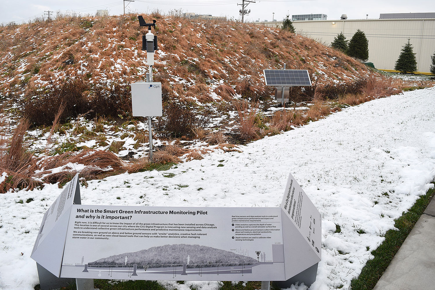
But how do you know if green infrastructure is working? It's a challenge: the technology is new, it's meant to be spread out over many small installations, and it combines a lot of functions into one installation, like retaining water, filtering it, and diverting it into surrounding soil.
That's the aim of Smart Green Infrastructure Monitoring, the latest project to emerge from UI Labs on Goose Island, an incubator meant to foster tech collaborations like it. It's a system of sensors that combines weather information with surface and groundwater monitoring to determine how much water is present, whether or not it's entering the green infrastructure, and what's happening to the water when it gets there.
"One of the challenges with maintaining cities is that you have these vast numbers of small assets, and green infrastructure makes this problem infinitely more challenging than the historical approach to having large, civil engineering projects that deal with stormwater. Instead of having a million-gallon tank, you may have several-thousand gallon bioretention cells to store and treat this water. And those assets are much harder to track," says Marcus Quigley, the founder and CEO of Opti, a company that applies internet-of-things technology to stormwater management, and one of the members of the collaboration behind SGIM.
Above ground, the sensors monitor weather conditions to see what the green infrastructure is managing. Below ground, they monitor soil moisture and water quality to see if it's managing the water as it's supposed to.
The group is still determining which probes and sensors will be used in the system, but it will definitely measure pH and temperature, and "the initial set that's deployed in Chicago is a basic set of parameters around water quality," Quigley says. The system will monitor the quantity of water, how it flows, and if it's flowing.
The data is then communicated via cellular network into an analytics platform based off of Microsoft's Azure cloud service, where the performance of the different green-infrastructure installations can be monitored in real time. The system can also send automated alerts if something is malfunctioning—if the soil is not as moist as weather conditions would predict, the infrastructure might be blocked; if the water is infiltrating the surface but not being diverted, it may be overloaded with particulate matter from prior storms.
The first data has started coming in from a sensor at a bioswale at UI Labs' Goose Island headquarters, soon to be followed by a permeable-pavement site. According to Adam Hecktman, director of technology and civic innovation at Microsoft Chicago, they're expecting to start releasing the data to the public in the summer of next year. Then, six sites will start uploading to the city's data portal.
"They each represent a different type of green infrastructure, a different cost point in terms of the investment in the green infrastructure, different adjacent land uses, for example, other things that allow you to get a sense of how green infrastructure performs in different locations with different approaches," says David Leopold, director of program management at City Digital, the UI Labs-based consortium that's also behind the recent Underground Infrastructure Mapping pilot.
The goal is for the city to have comparative data from different types of green stormwater infrastructure in different locations—and if other cities adopt it, even more data points about what works best.
"Places flood in different ways," Hecktman says, so the data project is meant to figure out which green elements work best where. This way, other cities can look at the data and figure out how green infrastructure can fit into their own plans.