When the Chicago Riverwalk is completed in 2016, it will be the city's most visible and ambitious new public space after Millennium Park, which just celebrated its 10th anniversary. And like the park, it represents the further evolution of the downtown landscape from an industrial corridor into a recreational center, and the reclamation of the Chicago River from a shipping canal-slash-sewer into a centerpiece of 21st century Chicago—a stated goal under the new administration, which recently brought in Jeanne Gang to design boathouses for the river's north branch.
Advertisement
To do that, the riverwalk will have to reintroduce Chicagoans to the river in the language of architecture and design. That's the job of Gina Ford, a landscape architect and chair of the Urban Studio at Sasaki Associates, which is working with Ross Barney Architects on the project.
Ford comes to the Chicago Riverwalk with years of working on river and shoreline projects, such as Sasaki's redevelopment of Cedar Rapids, Iowa after the entire downtown was flooded, some of it beyond repair, in 2008. As with Gang's work on Northerly Island, the Riverwalk plan explicitly integrates the natural and the recreational into the city's plan, "adding this generation's layer onto the river," Ford says. "For us, that was really recreation and ecology."
You've said that the Chicago River canyon is the kind of place that architecture students dream of getting to work with when they're in school. What were your first reactions when you started on the project?
We felt really, incredibly honored to be there, because we were brought to Chicago to interview for that project with Carol Ross Barney, a fixture of Chicago architecture, and has been a frequent collaborator of our office. I'm a relatively young designer, comparatively, and it was a humbling thing, because that space continues to be humbling—how iconic it is, how memorable the landscape is. Whenever you see any movie about Chicago, there's always a flythrough of that space.
I think it's because there's so much layered history that's visible in one view. You've got very modern architecture, and beautiful early American early architecture side by side; and you get an industrial waterfront with a Beaux Arts facade. The river itself is awesome in how much it's a working river, with so much traffic on it.
The riverfront right now, at the ground level is…
Pretty shabby.
Yeah, bordering up against Lower Wacker, Lower Michigan. It's humbling, but it's also a bit forbidding. How'd you begin to approach that aspect?
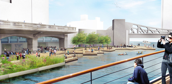
We benchmarked different riverfront projects around the country. We looked closely at places like the San Antonio riverfront, and our own work in Indianapolis, and we looked at best practices for accessibility. There was a question about how often you have to have accessible walkways between the lower and upper level.You know, what's the right rhythm of that so you create a sense of safety and accessibility? You can imagine that, with 22 feet of grade change, it's hard to incorporate vertical circulation in every room [i.e. section of the riverwalk]. So we did a lot of benchmarking and looked at other communities and what they'd done, and established that it should be every third block at a minimum, that there should be vertical access between Upper Wacker and the lower riverwalk, which is what gave birth to the river theater, which is the third space in the sequence. And then three more spaces after that, what we call room six, the confluence, and vertical circulation there

And there's the question of how you visually connect the upper and lower spaces. CDOT was adamant that we have some physical design expression in each space where you could see the lower level. In most of the rooms that happens through tree canopies. One of the issues now is that when you're at Upper Wacker, you can't see the riverwalk very well. So you have to have something vertical that bridges that vertical gap that signals something happening down there.
Advertisement
What else do you think, in your experience of the river walk?
I'm interested in the retail component; I know they've had trouble with that at the Trump tower, in that retail space, finding retailers. When I spoke with someone at SOM about the riverwalk, they talked about how narrow it is. How are those spaces designed to allow for retail?
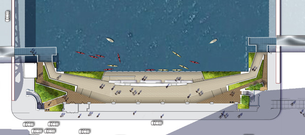
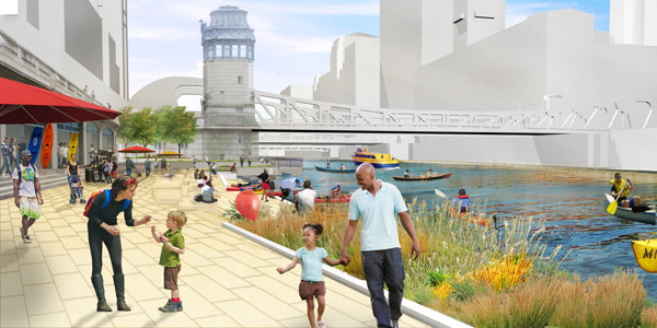
It's different from room to room. The marina room, which is the first in the sequence—it was always our strategy that it would be the major food and beverage space, so it has an upper dining terrace and the built-in bar along the edge.
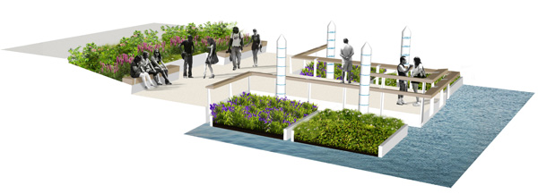
It is possible to do food and beverage in the arcade spaces, it just can't be a full built-out kitchen. It has to be a smaller amenity. Our job was to shell each of the spaces to make sure they had the right utility hookups, to make sure they were secure, to make sure we had storage and access from Lower Wacker at certain increments. For instance, under the river theater stairs, there's a whole series of storage spaces that can be used by retailers.Then, each of those spaces has a slightly different character. The marina's kind of an enclosed space that has a storefront to it. I think the cove, the second space, will also have that. It's always been our thought that maybe the retail in the cove is not food and beverage, maybe it's more small-scale vendors, seasonal vendors, and potentially human-powered craft-related vendors—if you can imagine, actually renting a kayak from the cove room. The water plaza, that's really going to be a whole series of changing rooms and rest rooms associated with the interactive water feature
The last space is the jetty. That room we're just keeping a completely open arcade, because we see it as an open-air classroom space. We try to build in diversity and flexibility so that we can test programs over time and see what works, and not commit ourselves to full-out kitchens in every room, a fixed idea of what might work.
This idea of "rooms"—I was trying to think of other urban spaces that use that concept and couldn't. Is this a new idea in urban space?
We hope so. We went through like three design iterations in the beginning, like in any design process you give the client a lot of ideas, and then you come to what's the most interesting, and sometimes it's an amalgam of all three.
Our three big ideas from the beginning were, one, we called it the "gradient." You basically have the civic crossroads of Chicago at Michigan Avenue and the river; moving westward, could it slowly become more environmentally focused? So it goes from being civic, hard-scaped, to much softer. You see a bit of that in the plan: it goes from the marina room, which is very formal, to the jetty, which is very informal and much greener.
The second idea was this notion of the river theater as the heart of this new district. You'd do something very provocative, gutsy, audacious in that center space, and let the other two be very muted and much more about walkways. And you see a little bit of that, because the river theater has persisted as this very different space in the sequence.
And the last one is what we call "river typologies," which is the one most people felt favorable to. In that one, we basically had done a really careful assessment of each block, and tried to understand what's unique about each block that we could riff off of from a design perspective.
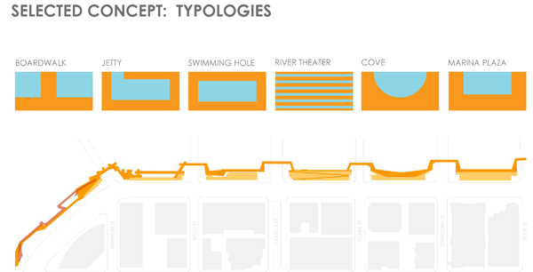
When you're in the first space, near Marina City, it plays this very significant role in your experience of that space. The corncobs themselves, the towers, but also this whole ground level of activities that's happening—this boat ballet of people moving in and out of the marina below Marina City. We wanted to create a whole space that looks at that. So we created steps, and this folded-seating element that was about sitting and watching the life of the river.
The cove, according to our boating specialists, Moffatt and Nichols, was the safest place for human-powered craft, because of the bend of the river and the confluence.
The river theater was the third in the sequence, so from an accessibility point of view, it really made the most sense to do our vertical circulation there.
The water plaza came out of an observation that the light levels of that room are much higher than anywhere else. It has much less dense construction, and a reflective building across the way, so it has significantly more light. If there was any place to do a water feature, it would be there.
Advertisement
And the jetty was the closest to Wolf Point, which is the closest thing to a live river bank you have on the main branch—one little strip of green on an otherwise gray edge. So we thought, let's riff off that and create a place of greenness here.
It's interesting because it really came out of that fine-grained assessment of those spaces and what we could be inspired by in each place. But wanting, also, to make sure that it had continuity—that the walkway was always the same width, that it had the same materials throughout. We don't ever introduce unusual materials to each room; each room is crafted out of the same material language to create continuity. It's just its shape and its adjacencies that give it its own character.
Speaking of visual language, how do you create horizontal continuity from the canyon to the river?
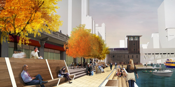
We wanted to preserve as much of the Wacker viaduct infrastructure as possible, and work on lighting strategies to celebrate that piece of architecture in and of itself.
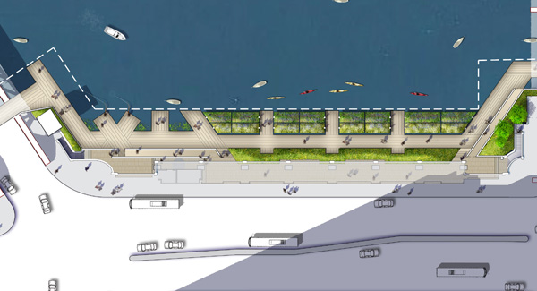
If you think about the edge treatment that runs along the entire riverwalk, one thing that's new here, and that will be new to the main branch, is that we drop that whole edge elevation down as close as we could to the water, and that's pretty consistent between the spaces.
It doesn't sound like a huge change, but it's actually going to enable a lot more boat docking, and a lot more interaction between the water sheet and each of the plazas itself. I think it will have a much more integrated feeling. And it will have a continuous expression of the Wacker Drive viaduct throughout.
We developed a material language for the project where, anything that's touching the Wacker Drive viaduct, up against that structure, is always made of materials that are incredibly sympathetic to it, always granite or limestone, which are two fundamental materials. Everything outside of that, that's low, against the river, has a different material quality that's a lot more rugged. A lot of precast concrete, metal grating, and stainless steel material.
Advertisement
There's continuity that you'll be able to see from across the river that will make it feel, I think, contextual within that architectural frame, if you will.
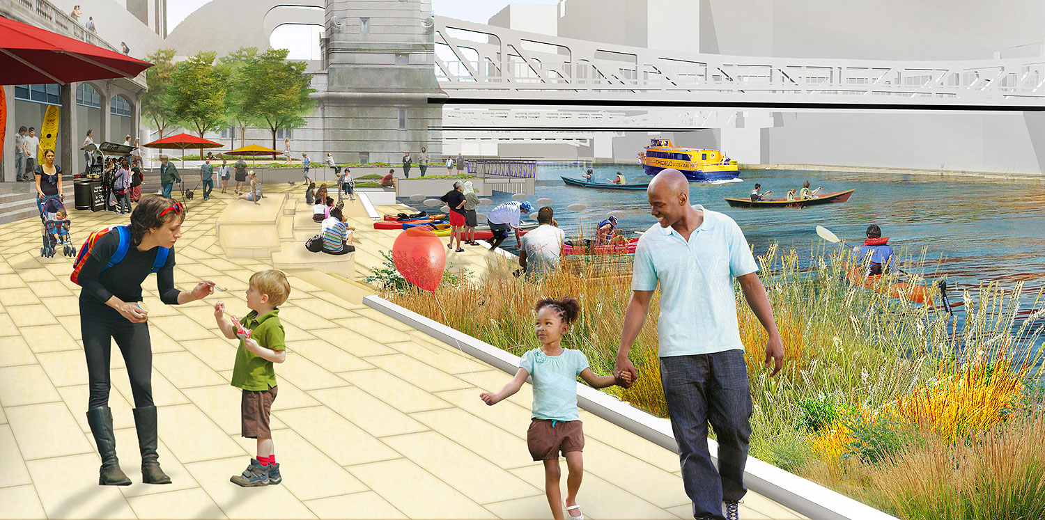
Lowering the grade of the riverwalk actually does seem significant to me. Chicagoans are kind of wary of the river, probably because of its history as an industrial channel. And as kind of an open sewer.
We work on riverfronts all over the country. I think the whole Wacker Drive section was created in a time when there was an idea from Burnham about civic promenades, and really the river was something to be viewed and promenanded along. In modern culture you see this everywhere from New York to Texas to California—much more recreational life along the river now.
ArchDaily had a funny piece about how all our renderings show kayakers, and there really aren't that many kayakers in the world. But in reality, you're there, you see it—it's pretty constant. Party boats, kayakers; I don't know if you have stand-up paddle-boarders, it's probably too much of a risk to get wet.
It's also important economically to lower the edge, because the city can have a lot more lease space for boat traffic. There'll be new water taxi stops, the potential for new tour boats, and all of that helps to make the economic case for the investment.
And below the surface, there's going to be things going on that you can't see that's part of the environment—like the things you're working on inspired by the fish hotel.
It's funny—that's probably my favorite part of the project, and probably the lowest-cost thing we're doing, just plywood and nylon rope.
We started off thinking about the jetty, really understanding the fish hotel as an idea done in a homemade and experimental way. When we saw it, we thought there should be a whole space devoted to a floating wetland idea. We worked closely with our ecologist here to understand what it would mean to actually create fish habitat in this space, and something that would really work, and there's all of this really low-tech… like the pole hula, it's basically just nylon ropes attached to the edges of the caissons that hold up the walkway, that create places for fish to hide, and plywood attachments that are called lunkers, that basically have gravel in them, that are good for amphibious insects, and therefore fish, since it's basically what they eat.
We wanted to create this underworld of fish habitat that you won't see at the surface, but hopefully you could… I know that they monitor the fish hotel, and they know what kind of species come there. Obviously since Asian carp is such a big issue on the river, we're trying to promote native ecosystems to thrive.
I've never detailed anything like that in construction documents, but it was like, "no, team, we really have to figure out how to make space for the fish here." The space doesn't stop and end where humans inhabit. There's this whole underworld.
When you spoke about Sasaki's work at RISD, one of the themes that ran through your waterfront work was flooding. How does that play out throughout your work across the country?
I grew up at Sasaki; I've been at Sasaki 17 years, and I apprenticed my first 10 years doing waterfront work in Detroit, Columbus, Ohio. It was very much working with the Army Corps to integrate things like levees and flood protection. And the last 10 years of my career have really been focused on resiliency; we've had a lot of work in the past decade related to flood-recovery work and post-disaster waterfronts, which is a new specialization, I guess. It started with the project in [Cedar Rapids] Iowa, and it manifested here in post-Sandy work on the Jersey shore, and we're just starting a competition in New Orleans about the Mississippi River Delta and its challenges, like sea-level rise. It's a huge part of our work.
On the Chicago River, it's a very controlled river. It doesn't have such huge extremes, and it can be controlled. There's a certain elevation that, when the water hits it, the locks go into operation; they can basically drain the river. We didn't have to worry so much about the really significant outlier events that can happen on more naturalized rivers.
Advertisement
But we did make sure that, within the spectrum of what will flood, we detailed all of the landscape features to be incredibly resilient, from paving material choices—which is what I was saying about the material palette, using a rugged pre-cast [concrete], to avoid it having issues with floods. Knowing where to put all our electrical equipment, all the stuff that's needed to power the rooms and the vendors, keeping them out of flood elevation.
The city will need to manage for flood. And they do that today. All of the underbridges, the ones that pass under Carol Ross Barney's fantastic metal sheathing, those flood pretty much annually now, I think. So we can expect that the riverwalk, large parts will flood annually in the future. We just designed to make sure it would be resilient and easy to clean up after, easy to operate.
You touched on Burnham earlier. How did you work with his legacy?
About a decade ago, we were one of the three finalists for the Burnham Memorial Competition that the AIA Chicago held. We were the only non-Chicago firm that was asked to compete in that, and we ended up one of the three finalists. So we had a probably nine-month period of really getting to know Burnham very, very well.
Here, what was so interesting about it, was the sense that there are all of these layers that are so visible on the river. These hulking, metallic bascule bridges with big rivets, and it feels incredibly industrial, and it feels of that time, when the river was really an industrial conduit, and they shake and they vibrate when you walk across them. It's very visceral.
Then you have Burnham's legacy of this Beaux Arts, limestone, City Beautiful expression. This promenade, which is a very different layer.
We felt that our contribution had to be adding this generation's layer onto the river. For us, that was really recreation and ecology. Those two things should be present in this new layer that we were adding onto what has been a palimpsest of historical layers of the city.
The focus on ecology, and of the changing of the seasons in the jetty, connects it, in my mind, to the work of Jeanne Gang on Northerly Island, putting the city into an environmental context.
Everything I work on, I work really closely with ecologists. They have a completely different way of reading the landscape, and understanding its health. We look at it—landscape architects look at it—from an aesthetic, visual point of view, or a programmatic one. Ecologists can really look at a space and tell you how it's functioning from many, many different perspectives. And I think it makes for really rich layering of spaces that can be educational, that can make visible these forces that you don't see.
I think that was really the inspiration for the jetty. A lot of Jeanne Gang's work, which I'm a huge fan of, is trying to figure out how to make concerns about sustainability part of incredibly vibrant urban spaces.
It also adds a fourth dimension to it, a dimension of time, which people don't always think of when they think about architecture.
It's been really fascinating; we're just finishing the documentation for the water plaza and the jetty. Those drawings are getting finalized. The process of designing those floating wetlands has been one of the most fascinating processes I've ever been part of. To your point about time, we have to design these floating planters that will survive heat, drought, ice floes in the wintertime, and basically it came down to designing them like boat slips; they're like winterized boat docking. We have them tethered to poles like you'd see in a marina. The time dimension is a nice thing to have to think about—something surviving years, or many years, in the river.
And hopefully that will be an interesting part to come see that space when it's thriving in the springtime, and when it's in full bloom.