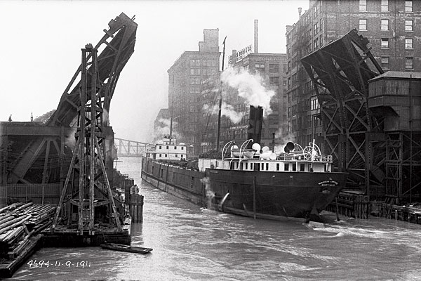
A barge passes through downtown Chicago along the South Branch of the Chicago River in 1911. This is one of nearly 22,000 recently found photographs taken by the Sanitary District of Chicago.
Related:
PHOTO GALLERY »
A chronicle of the reversal of the Chicago River
It’s something of a miracle that the photographs on these pages exist. Taken between 1894 and 1928 to document the reversal of the Chicago River and its effects on the region, they sat in storage for so long they were nearly forgotten. Discovered by accident, they depict the Chicago River and its burgeoning metropolis a few decades after the Great Fire, and they show the Illinois River before water from the Chicago River doubled its size and transformed the surrounding landscape forever, inundating downstate farms, eroding shorelines, submerging islands, and filling backwater streams, marshes, and lakes.
Until the Chicago River was redirected toward the Mississippi via a 28-mile drainage canal—the building of which ranked among the epic engineering feats of its age—the city’s raw sewage simply flowed straight into the river, threatening the supply of drinking water in Lake Michigan. Chicago Sanitary District officials were rightly proud of the canal they were building to whisk the sludge away, so in 1894 they hired photographers to begin documenting the work. Over the next few decades, they produced nearly 22,000 glass-plate negatives offering an entirely new view of the region—from the river. After the canal was completed, the photographers shifted their focus downstream and chronicled the impact of the increased flow of water on the Illinois River valley. The district used some of those photos in lawsuits filed by downstate farmers claiming damage to property, but most never saw the light of day. Eventually the glass plates wound up in wooden crates that were stored along with thousands of film negatives shot in the 1930s and 1940s.
In the late 1990s, employees at a plant in Des Plaines run by the Metropolitan Water Reclamation District of Greater Chicago (successor to the Sanitary District) began to complain of an acrid smell emanating from the basement. The source turned out to be the film negatives, which were deteriorating with age. District officials ordered the reeking film disposed of. But sitting nearby were the crates, 128 of them stenciled by year, containing the older glass-plate negatives—in nearly pristine condition. They were inventoried and scanned, then transferred to the Illinois State Archives in Springfield, where they remain today.
We got our first peek at those images in 2000, after seeing a couple of the canal construction shots in a book and wondering what else was in the collection. Arranged chronologically, the negatives showed a wild hodgepodge of sites—pictures of the North Branch of the Chicago River next to downstate waterfalls. The pictures were intriguing, but without any additional information, we didn’t know what to make of them.
Years passed, and other projects intervened, but we never stopped thinking about those photos. Early last year, we went back for a second look. This time, we discovered the key to the collection. Each negative had an etched number and a date, which corresponded to entries in tiny field books left behind by the photographers. When we connected that information with mile markers on the rivers, we could pinpoint exact locations. All of a sudden, the photographs had meaning.
Even so, many shots seemed little more than pedestrian views of downstate farms—a barn here, a cornfield or farmhouse there. Then, one day, Michael put several of the digital scans side by side. “Look,” he said. “These horizon lines match up.” It was a eureka moment, for it became clear that many of the plates were meant to be viewed as sets of two, three, or four or more. Suddenly pictures with little artistic value combined to form sweeping panoramas of a world that no longer exists—the grand prairie in its final days. These photographs of long-lost landscapes, the most stunning part of the collection, are the focus of our new book, The Lost Panoramas (CityFiles Press, $45). Many can also be seen in an exhibition at the Peggy Notebaert Nature Museum that runs through the end of the year.
The reversal of the Chicago River also reshaped the urban landscape. The Sanitary District replaced dozens of bridges and their channel-clogging support structures with drawbridges, constructed the Cal-Sag Channel and North Shore Channel, and straightened long stretches of the Chicago and Calumet Rivers, all to maximize the river’s flow toward what is now known as the Chicago Sanitary and Ship Canal. The photographers who documented that work captured a rare view of the city. Here was a Chicago not of grand boulevards and architectural treasures but of cranky swing bridges, crumbling streets, flour mills, warped houseboats, and animal blood oozing into the river. The raw honesty of those photos makes for a singular collection.
Though the reversal of the river was an engineering triumph, it was also an environmental flop. By 1921, half of the Illinois River’s wildlife habitat had been eliminated through submersion, erosion, or the construction of levees. And few fish lived in the sewage-choked Des Plaines River west of Chicago and the Illinois River. (After wastewater plants opened in the 1920s, the river began to rebound.)
These photos show Chicago on the path to becoming a great metropolis—and what was lost along the way.