Chasing Waterfalls Amid Sandstone Canyons
STARVED ROCK STATE PARK
North-central Illinois
Drive time 1 hour 45 minutes
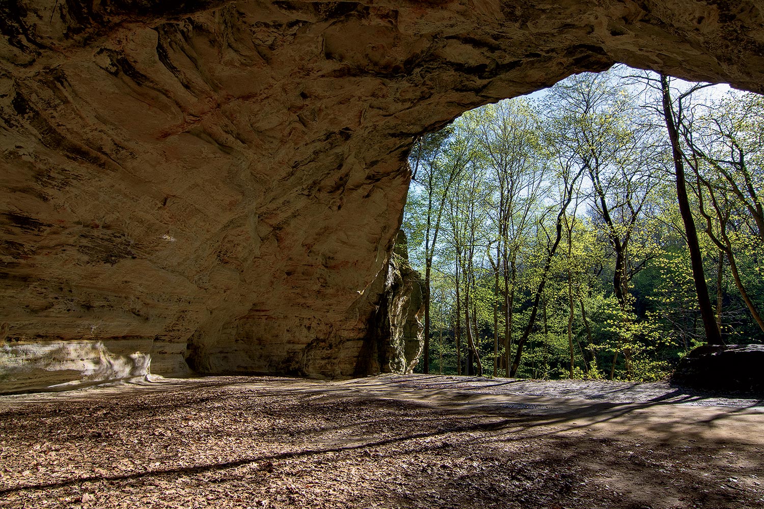
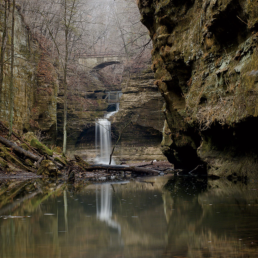
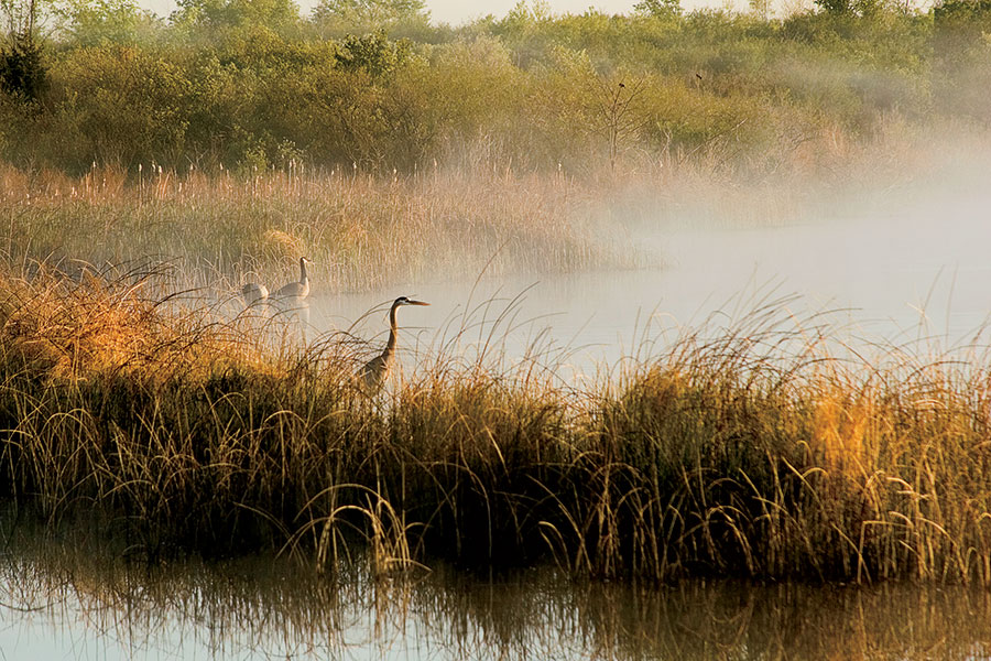
Summer may be peak season at this crown jewel of Illinois parks, but its legendary canyons, bluffs, and trails are arguably at their most appealing between March and May, when snowmelt and spring rains feed Starved Rock’s stunning waterfalls. Follow the trails marked in green to the falls at French, Wildcat, LaSalle, Ottawa, Kaskaskia, Illinois, Aurora, and St. Louis Canyons. The sandstone formations, carved millennia ago by glacial forces, make for eye-popping scenery in their own right — and are best admired from the trail, because climbing the notoriously crumbly rock is ill advised. Or tackle the Starved Rock and Sandstone Point Overlook Trail, a four-mile loop, rated moderate in difficulty, that offers a commanding view of the Illinois River. The park’s name comes from the death by starvation of a band of Illiniwek seeking refuge on a butte here during a battle over the death of Ottawa chief Pontiac in the 1760s — a solemn reminder of whose land you’re hiking through and the privilege of communing with it.
Look for Bald eagles. The Plum Island Eagle Sanctuary, which occupies a 45-acre island in the Illinois River opposite the park’s visitor center, is a wintering area for the birds. In spring and summer, you’ll have a chance of seeing a mating pair that are permanent residents.
While there Reward your exertions with a pint at the Lone Buffalo, a taproom in nearby Ottawa operated by Tangled Roots Brewing Company.
Communing With Illinois’s Original Landscape
MIDEWIN NATIONAL TALLGRASS PRAIRIE
Northeastern Illinois
Drive time About an hour
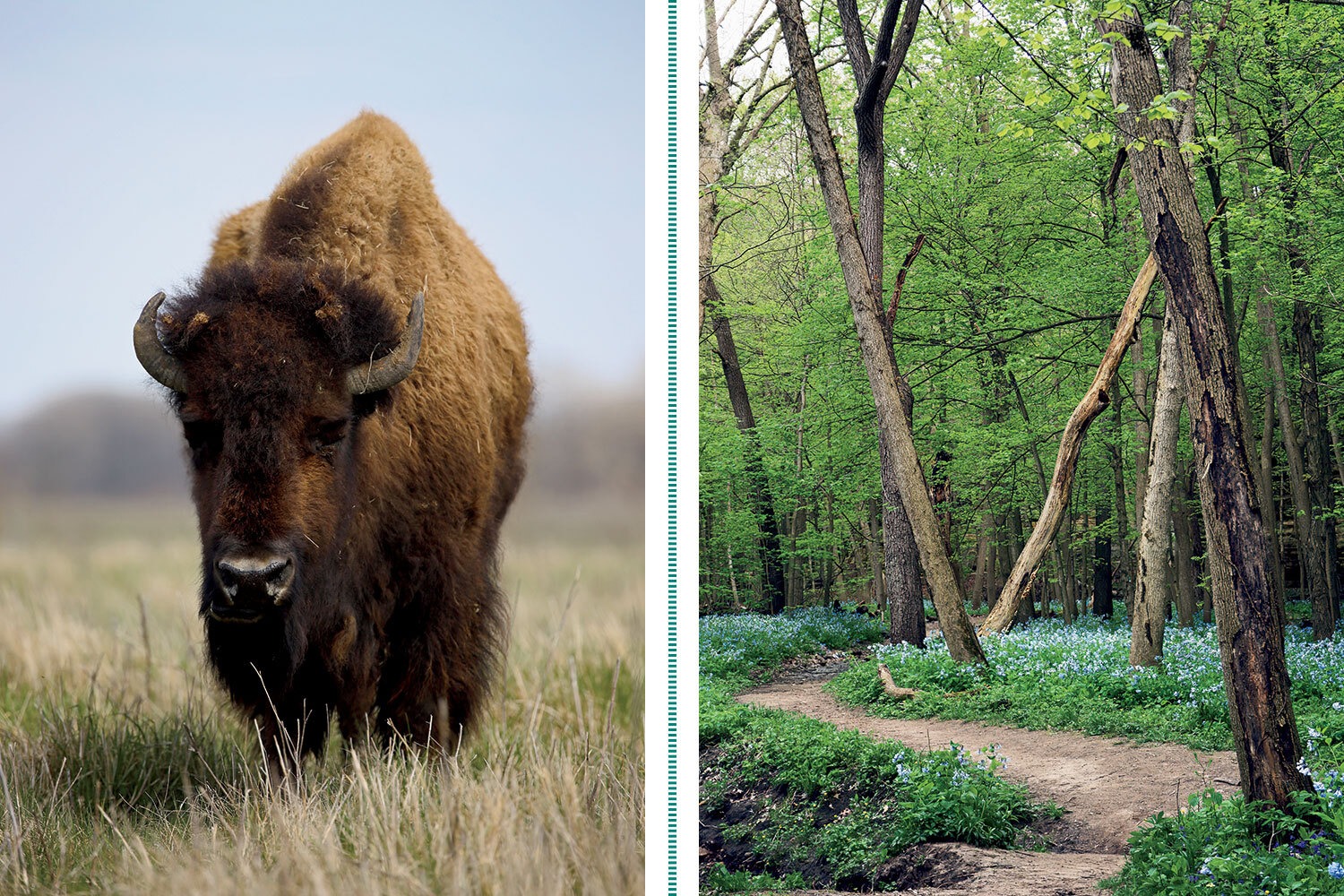
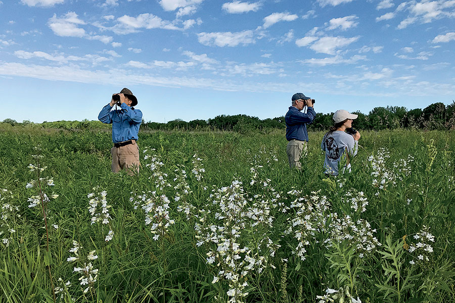
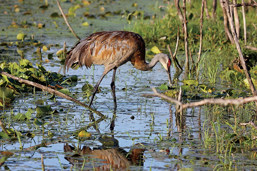
Bison, the prairie’s once-abundant original inhabitants, were reintroduced in 2015 as part of a conservation initiative at this 18,500-acre preserve, which occupies the site of a former ammunition plant and is the first federal tallgrass prairie in the country. You can’t walk among the bison — currently the herd numbers around 50 — since they roam in pastures fenced off from the park’s 33 miles of trails, but sightings are common. Years of painstaking restoration of the area’s tallgrass habitat has resulted in an unparalleled variety of birdlife. Keep your eyes out for sandhill cranes, black-necked stilts, dickcissels, Henslow’s sparrows, and the rare black-billed cuckoo. Created in 1996 and considered one of the most significant conservation triumphs of the 20th century, Midewin offers a chance to experience the natural prairie that covered much of the Midwest but is now all but obliterated.
Look for A prehistoric glacial erratic. Follow the Henslow Trail to where it crosses Route 53 to see this 19-ton boulder that was pushed south by an ice sheet, possibly from as far as present-day Wisconsin.
While there The nearby village of Elwood boasts a rare attraction: a paved section of the original Route 66 — America’s Mother Road — that you can actually drive on. (It’s on what’s now Douglas Street.)
Breathtaking Views of America’s Mightiest River
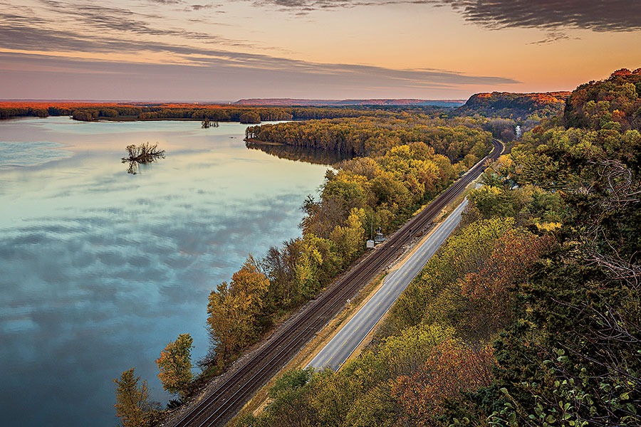
MISSISSIPPI PALISADES STATE PARK
Northwestern Illinois
Drive time Just under 3 hours
The riverbank bluffs, or palisades, that are the centerpiece of these 2,500 acres make for exhilarating hiking and gorgeous panoramas. Fifteen miles of relatively short, interconnected trails ascend the bluffs and plummet into cool, fern-filled ravines, offering views of erosion-carved limestone formations with names like Indian Head and Twin Sisters. But you don’t have to scramble to earn your views: Several paved paths lead to platformed overlooks that take in the confluence of the Mighty Miss and the Apple River. Have an old-fashioned picnic in one of the shelters built in the 1930s by the Civilian Conservation Corps. In spring and summer, look for the colorful splendor of brightly blooming lobelias and bluebells.
Look for Woodland mammals. Weasels, muskrats, and badgers make their home here.
While there The historic downtown of nearby Mount Carroll has rightly earned a spot on the National Register of Historic Places. It features brick-paved streets and remarkably well-preserved 19th-century Victorian houses.
A Birding Bonanza Less Than an Hour From Downtown
PALOS PRESERVES
Southwestern Cook County
Drive time 45 minutes
This 12,000-acre complex of trails and protected lands — constituting the largest forest preserve system in Cook County — is about as remote-feeling as you can get without leaving the metro area. The Yellow Trail is an eight-mile gravel loop that offers a decidedly away-from-it-all vibe and traverses the Cap Sauers Holding Nature Preserve, the largest roadless area in the county. Bring binoculars: Bald eagle sightings are common, and the preserve hosts an exceptional variety of less glorified birds, including summer tanagers, eastern phoebes, pileated woodpeckers, and Louisiana waterthrushes. Seeking a workout? Enter the Swallow Cliff Woods off Calumet Sag Road and sprint up the limestone stairs leading to the top of a 100-foot bluff. Worried about getting lost in all that wide-open space? Relax: Virtually all Cook County Forest Preserve trail maps are accessible on your phone.
Look for Baby wood ducks falling from the sky. The waterfowl nest in tree cavities, says Cook County Forest Preserves ecologist Kristin Pink, and the babies will occasionally plummet out and scamper toward water.
While there Make the day an action double-header by also hitting the Forge: Lemont Quarries, a new adventure park eight miles away featuring aerial rope courses, laser tag, and more.
Cliffs, Bluffs, and Dells Without the Crowds
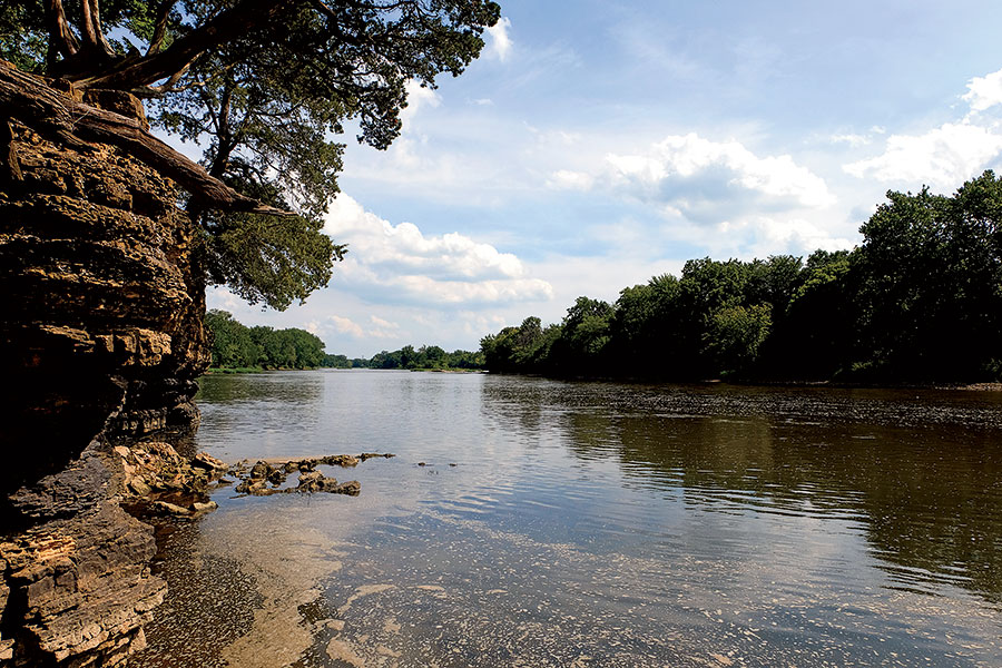
MATTHIESSEN STATE PARK
North-central Illinois
Drive time 2 hours
This 4,500-acre expanse of woods, canyons, glens, and creeks possesses virtually all the natural beauty of Starved Rock — the bigger and better-known state park just a few miles to its north — minus the throngs of nature-deprived city folk. Situated along the Vermilion River near its junction with the Illinois, Matthiessen has a less extensive trail system than Starved Rock’s (just five miles of groomed paths), but those trails traverse remarkably variegated terrain and can take you deep into the park’s signature wooded valleys, or dells. Watch for white-tailed deer along the trails, some of which cross the rushing creeks that empty into the Vermilion and sluice over the dells’ terraced rocks in sprightly cascades. Sorry, no swimming, no matter what you’ve seen on TikTok.
Look for Winsome yellow lady’s slipper orchids (a.k.a. moccasin flowers). They flourish in the nature area bordering the dells.
While there What’s better than a blood orange margarita after a vigorous hike? One accompanied by some light shopping for handcrafted jewelry, teas, scarves, and soaps. The Ottawa wine bar Cat’s Eye and its gift boutique, A Mess of Things, offer both.
From Forest to Beach in a Few Bounding Steps
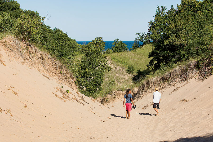
INDIANA DUNES NATIONAL PARK
Northwestern Indiana
Drive time About an hour
Encompassing rivers, woodlands, prairies, wetlands, and, of course, the eponymous hills of sand, Indiana Dunes National Park is one of the most ecologically diverse preserves in the nation. With 14 trail systems totaling more than 50 miles, the park is as welcoming to visitors seeking a little birdwatching as it is to those intent on an all-day trek. “You’ve got incredible natural features that aren’t found anywhere other than the south end of Lake Michigan, including oak forests that grow right out of the sand,” says hiking advocate Jay Readey. A great introduction is the 4.7-mile Cowles Bog Trail, which takes in oak savanna, ponds, marshes, swamps, and beaches, as is the justifiably popular Dunes Succession Trail, which rewards hikers who scramble to the top of the dunes with gorgeous lake views sheltered by fragrant jack pines.
Look for The distant Chicago skyline. Seen from the tranquil heights of the dunes, it’s one of the most memorable views of the city you’ll ever have.
While there Grab a burger at Industrial Revolution Eatery & Grille in Valparaiso, 20 minutes due south, and make a night of it by catching a movie at the 49er Drive-in Theatre, open April through October.
An Unsung Woodland Gem
SEVEN BRIDGES IN GRANT PARK
Southeastern Wisconsin
Drive time 1 hour 30 minutes
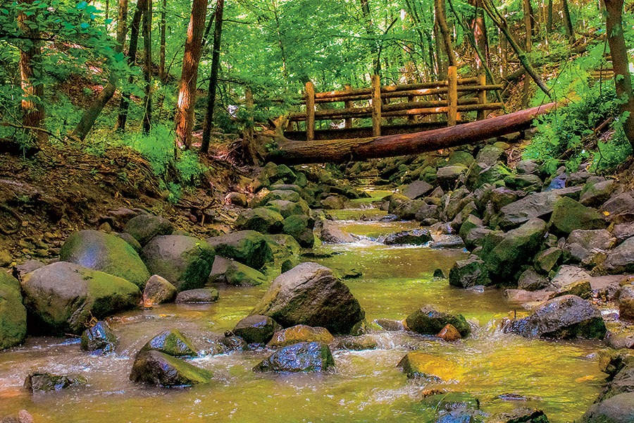
An invitation by Romantic poet William Cullen Bryant beckons at the entrance of this easily overlooked county park south of Milwaukee: “Enter this wild wood and view the haunts of nature.” Inscribed on a covered wooden bridge, the words offer a fitting welcome to this beguiling expanse of deeply shaded ravines and stone paths that abuts an intimate Lake Michigan swimming beach. Flanked by trout lilies and trilliums, the trail weaves through birch, maple, and white ash trees and leads to steep stone staircases, nooks with benches for resting, and those seven footbridges — creating an enchanted-forest vibe that kids will dig. Keen observers crossing another of the bridges will notice a second Bryant verse, one that captures the appeal of the place: “May the God-given peace of this leafy solitude rest upon and abide with thee.”
Look for The distinctive limestone pavers on the trail. Those and the ones forming the retaining walls came from the nearby Lannon stone quarry, which produces a pretty dolomite used to clad countless buildings in the area since the 1850s.
While there In Milwaukee, just 10 minutes north, pick up a dry-brined rotisserie chicken from the beloved bistro Goodkind or sip a cortado on the patio of Colectivo Coffee.
A Journey Into the Ice Age
KETTLE MORAINE STATE FOREST, SOUTHERN UNIT
Southern Wisconsin
Drive time About 2 hours
When the ice sheet that covered much of North America retreated some 12,000 years ago, it left a distinctive landscape of hills, kettles (surface depressions), ridges, and lakes across a great swath of what is now Wisconsin. Those natural features take pride of place on any stretch of this 23,000-acre forest’s 100-plus miles of trails. A good option for glacially minded first-time visitors is hiking the segment of the 1,000-mile Ice Age National Scenic Trail that cuts through a particularly gorgeous stretch of the park. You’ll see ancient sedimentary formations such as kames (gravel or sand mounds) and eskers (long, winding ridges) and, if you’re observant, plenty of flora and fauna too: The park is home to red foxes, turkeys, and coyotes and an abundance of wildflowers, including forked aster, yellow gentian, and eastern prairie fringed orchid. Families and dog owners can tackle any of the loops in the Nordic Trail system, which extends across gently rolling terrain traversing pine and hardwood forest and open plains.
Look for The ruins of an old resort. Complete with a still-active artesian spring and trout pond, it rises alongside the half-mile loop trail Paradise Springs.
While there Venture to the nearby mill town of Whitewater for a farm-to-table meal at the Black Sheep, which sources from nearly a dozen local farms and fisheries.
A Riverside Ramble
KANKAKEE RIVER STATE PARK
Northeastern Illinois
Drive time About an hour
A mostly flat, woods-shaded trail forms the backbone of this 4,000-acre park hugging both banks of the river. Hardcore hikers might call the 10.5-mile paved and gravel route more of a walk than a hike, but for parents with stroller-age kids, it’s a chance to plunge into a distinctive natural habitat without having to put the kid in a carrier. A three-mile spur along Rock Creek, a tributary, leads to limestone canyons and a waterfall. That creek is rated as one of the cleanest streams in Illinois, and the naturally channeled Kankakee was recently ranked No. 1 for water quality in the state by the Illinois River Watch Network. All the more reason to bring your fishing gear: Smallmouth bass, channel catfish, northern pike, and walleye abound.
Look for The grave of Potawatomi chief Shaw-waw-nas-see. The trail running alongside Rock Creek leads to a boulder that marks it.
While there Scuba diving in Illinois? You bet. Nearby Haigh Quarry is a spring-fed, limestone-lined lake that’s been turned into a diving refuge.
Hidden Lakes and Pristine Dunes
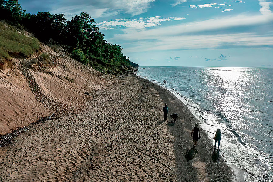
GRAND MERE STATE PARK
Southwestern Michigan
Drive time 1 hour 30 minutes
This 985-acre jewel hugging Lake Michigan’s eastern shore harbors a tranquil dunes habitat and three ancient inland glacial lakes called, prosaically, North, Middle, and South. A handicapped-accessible paved trail departs from the picnic shelter; a half mile in, the pavement gives way to a sandy footpath that forks right toward a mile-long beach backed by dunes, and left toward South Lake, which is nestled in an undeveloped natural preserve that’s home to waterfowl and songbirds. Beach-bound hikers can summit Baldtop, a 760-foot dune, before sprinting (or tumbling) toward the crystal waters of Lake Michigan. The National Park Service has named Grand Mere a National Natural Landmark, owing to its unique terrain and ecological diversity.
Look for The geological phenomenon known as aquatic succession. This transformation of glacial lakes into terrestrial habitat is happening right before your eyes with the three interdunal lakes. (Two other lakes beyond the park have already turned into bog forest.)
While there Southwest Michigan’s Makers Trail features more than 45 breweries, cideries, wineries, and distilleries within 25 miles of the park. Try a barrel-aged cider at Peat’s Cider Social, just across the road from the park.
Comments are closed.