Photo: Zbigniew Bzdak/Chicago Tribune
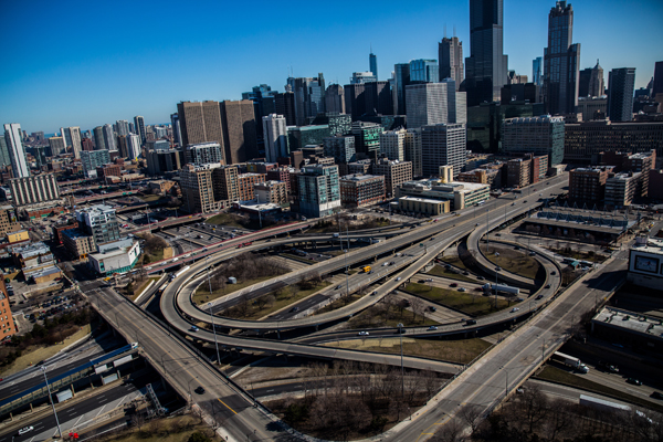
Looking at downtown Chicago northeast of the Circle Interchange, mercifully free of traffic for this photo.
You might have missed it, but last week in Springfield, Gov. Pat Quinn held a press conference to announce what roads, bridges, and railways in Illinois will receive a face lift over the next six years.
Standing beside Illinois Transportation Secretary Ann Schneider, Quinn unveiled the state Department of Transportation’s project list for 2014 through 2019, a diverse set of proposals that will cost $12.6 billion to see through. It will be covered by a combination of “anticipated” federal funds ($7.2 billion), state transportation dollars ($1.9 billion), local contributions, and forthcoming bonds. Most of the state’s focus ($9.53 billion) is still on road maintenance, while public transportation departments would see $1.8 billion worth of improvements.
By far the most expensive project on tap, by a magnitude of four, is a full rehab of the Circle Interchange, the annular maze of ramps just west of downtown that link Chicago’s major expressways. The Circle, or Spaghetti Bowl, as traffic reporters used to call it, was built 50 years ago, a crucial stretch of road in the area’s mid-century highway boom. For decades, Illinois politicians dreamed of erecting a network of “superhighways” radiating out of the Loop; in 1940, before World War II postponed construction, the city council even approved a regional map, straightforward and utilitarian, that looks nearly identical to what we drive on today.
When Congress passed the Federal-Aid Highway Act of 1956, the financial backbone of Eisenhower’s Interstate Highway System, Mayor Richard J. Daley started building with gusto.
- The east-west Congress Expressway (later renamed Eisenhower, “the city’s only Republican expressway,” as Mike Royko jokes in Boss) opened in October, 1960.
- A month later, cars flooded the Northwest Highway, later renamed for John F. Kennedy. At the ribbon-cutting ceremony on November 6, Gov. William Stratton told the Tribune that “bottlenecks are now broken,” while Daley went so far as to suggest that the highway’s inauguration “is as significant as the opening of the [Northwest] territory in colonial times—new lands for better living, better working, opportunity, liberty, and freedom for all.”
- Two years after that, then the widest highway in the world, the Dan Ryan, opened for business. During the planning stage, that expressway was infamously rerouted several blocks so the road could neatly seperate Daley’s Bridgeport from the public housing high-rises to the east.
The Circle Interchange, which connected them all, was constructed in stages over seven years, and opened for good with the Dan Ryan in December of 1962.
On November 19, 1962, the Tribune ran a prescient piece titled “Experts Fret Over Dan Ryan Interchange.” Here’s the lede:
Four weeks before the opening of the Dan Ryan Expressway, scheduled for Dec. 15, traffic engineers are worried about what is going to happen at the interchange of this south route with the Congress and Northwest expressways. It is expected to become of one the most heavily traveled crossroads in the world, with slowdowns and backups in the morning and evening rush hours.
[…]
The ramp roadways are 20 and 22 feet wide and are intended for a single file of autos in ordinary free flowing periods … “We know we are going to have congestion at this interchange until a more comprehensive expressway system is completed in Chicago,” said William J. Payes, director of public works.
Payes was no dummy. By 1975, an Federal Highway Administration report showed that 42 of the nation’s 50 busiest interstate sections fell on either the Ryan or Kennedy. Ten years ago, the U.S. Department of Transportation ranked the Circle as the third-worst bottleneck in the country. In 2011, the American Transportation Research Institute named it the worst; 400,000 vehicles travel through the Interchange daily at an average speed of just 29 mph, according to GPS and onboard monitoring equipment. Lots of freight and commuter traffic, combined with single lane ramps and tight curves, leads to delays and crashes—almost three a day. An old coworker of mine used to call it “The Hot Corner,” a nickname I’ve always appreciated.
What does Gov. Quinn want to do with it? The state is very close to adopting a final redesign, the outlines of which the Tribune’s John Hilkevitch—a top-notch transportation reporter—laid out earlier this month:
Expanding I-90/94 from three lanes to four lanes in each direction through the Circle, to help ease bottlenecks. Currently there are five lanes north and south of the Circle, but only three lanes through the Circle Interchange section.
Doubling to two lanes the two most congested ramps: northbound I-90/94 to westbound I-290, and eastbound I-290 to northbound I-90/94.
Building a two-lane elevated ramp from the northbound Ryan (I-90/94) to the westbound Eisenhower. The ramp would begin near Taylor Street and fly over Halsted Street, then drop to link up with the Eisenhower.
"These lane additions coupled with smoother curves and flatter profiles on all the ramps will enhance the mobility through the interchange, including truck traffic,'' said Claffey, the IDOT spokesman.
In March, the Chicago Metropolitan Agency for Planning (CMAP) included the project in the “GO TO 2040” long-term transportation plan, which gives IDOT the opportunity to pursue federal funding. (Given the state’s financial woes, that is the only realistic way we could pay for it.) If and when construction begins, it would take about four years to complete.
Quinn’s office, citing estimates from “transportation planners,” notes that the changes will reduce traffic delays by at least 50 percent, saving drivers 5 million hours and 1.6 million gallons of fuel annually.
Not everyone in Chicago is so convinced. The Metropolitan Planning Council, a regional think-tank, has been vocal about its problems with the proposal. They cite CMAP’s own evaluation, from this past January, which determined “the project will do little to relieve congestion or spur economic growth.” (Indeed, the Circle Interchange was not among the 52 regional transportation projects that advanced to the evaluation stage during the initial GO TO 2040 process, completed in 2010, which included input from IDOT.)
Basically, any reduction in travel times will be offset by the addition of more drivers, and they’d rather see scare resources devoted to infrastructure that would increase access to public transit. Active Transportation Alliance Executive Director Ron Burke called it “at best, a short-term solution to roadway congestion.” Residents of Green Street Lofts, 400 S. Green St., are also up in arms, as one of the new ramps would stand right alongside their building.
It’s a story worth keeping an eye on in the next few months, even if you’re not a long-haul trucker or commuter who rides the Northwest Highway out to Schaumburg every day.