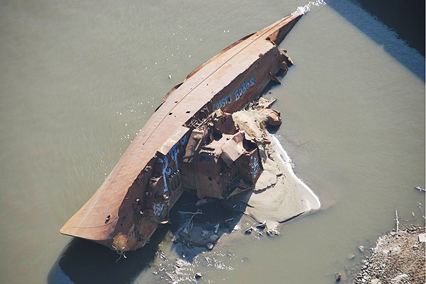
A World War II minesweeper at the bottom of the Mississippi River, exposed by dropping water levels, and recently tagged with graffiti.
The big weather story of 2012—and one of the biggest undersung stories of last year—has been the Midwestern drought, which quietly reached levels not seen since the multiyear drought of 1988-1989, and before that, the Dust Bowl. The Mississippi River could shut down to shipping traffic within a couple days:
Prime areas of concern are near the Illinois towns of Thebes and Grand Tower, where river-bottom rock pinnacles pose a risk to boats when the river is exceptionally low.
"That reach has historically been the rock-bottom part of the river and pretty much everywhere else on the mid-Mississippi is sand- and silt-bottom," said U.S. Army Corps of Engineers spokesman Mike Petersen.
The Corps has been dredging various soft-bottom sections of the river nearly round-the-clock for months to maintain a deep enough shipping channel, but a project to remove the most threatening rock pinnacles will not be completed until the end of January.
Within a couple weeks, the river could hit its lowest levels ever recorded at St. Louis; it's now the third-most-expensive weather disaster in the past three decades (based on estimated, preliminary data at least), behind Hurricane Katrina and just behind the 1988 drought, and well ahead of Hurricane Sandy:
While it will be several months before the costs of America's worst drought since 1954 are known, the 2012 drought is expected to cut America's GDP by 0.5 – 1 percentage points, said Deutsche Bank Securities this week. “If the U.S. were growing at 4 percent, it wouldn’t be as big an issue, but at 2 percent, it’s noticed,” said Joseph LaVorgna, the chief U.S. economist at Deutsche. Since the U.S. GDP is approximately $15 trillion, the drought of 2012 represents a $75 – $150 billion hit to the U.S. economy. This is in the same range as the estimate of $77 billion in costs for the drought, made by Purdue University economist Chris Hurt in August.
Unlike Sandy, the drought has been slow-moving and not very visual, notable for what isn't there. But the U.S. Army Corps of Engineers captured some remarkable aerial views of the river between St. Louis and Cairo, along the stretch of river where Thebes is located: a portrait of a shallowing, shrinking river that's about to grind to a halt.