On Wednesday, CDOT held a meeting to discuss the proposed Chicago riverwalk. I've got a column coming up in the next issue of Chicago that goes into the subject a bit more—what other cities have done well (San Antonio, London) and poorly (Indianapolis), and what we can learn from them; it also comes up in David Bernstein's piece on Rahm Emanuel (hint: the word "legacy" is involved). So I was interested to see what CDOT said. The answer is not a lot new—see below for renderings—but they did offer up some estimates on the impact:
CDOT estimates that 2.8 million souls will visit the beautified and functionally connected Riverwalk annually, about a million shy of NYC's High Line but almost equaling Lincoln Park. Rosy estimate or realistic? If the spaces live up to the renderings and if seasonal obstacles are somehow solved, then its potential draw is great.
It doesn't seem too rosy, in comparison to other big Chicago attractions. To put it in more Chicago context, 2.8 million visitors is about half of what Millennium Park is estimated to draw, and about 30 percent of what Navy Pier drew in 2012. The San Antonio riverwalk, in terms of visitors, falls somwhere in between Millennium Park and Navy Pier. It's a masterpiece, but it will take a long time for us to equal it; it started modestly in the late 1930s and has been growing since, to about five times longer than Chicago's will start.
In that sense, Chicago's advantages are also disadvantages: the river corridor between State and Lake is a spectacular urban environment, but because it's so spectacular it's not a blank slate to work in (San Antonio first wanted to turn its river into a concrete-covered sewer). Anything we do has to be either built out into the river or crammed up alongside Wacker, giving architects and engineers precious little room to work with. Making it a mixed-use corridor will be a challenge, though not an insurmountable one.
One underrated use of the proposed riverwalk will be as a transportation corridor—a seamless, or at least seam-limited, route along the south bank of the river. Aaron Renn, who blogs at the Urbanophile (and who has lived in both Chicago and Indianapolis), accurately described Chicago's current riverwalk as less a walk than "patios," with some nice places to sit but divided by the bridges. If you've tried to walk it, you'll understand; it's silly to go down the steps, walk to the next block, and then ascend again just to wait for a light.
At the new Streetsblog Chicago, John Greenfield talked to Michelle Woods, CDOT's project manager, and Michael Riordan of the River North Residents Association about its potential:
Michael Riordan: I can see this as being a pedestrian commuter route for people who live and work in the Loop. I walk to work as much as possible and I think it will be a terrific amenity. [Riordan added that he’d like to see an extension of the existing river path along the North Branch from Chicago Avenue to Erie Street, leading south to the riverwalk.] And I was hoping that your design would incorporate some kind of connection that will allow people to take the riverwalk from the lakefront to Franklin Street, and then take Franklin to the Wolf Point development, and up along the North Branch.”
Woods noted that it won't really be a bike corridor, save for perhaps early in the morning when it's less congested. Parts of San Antonio's riverwalk are bike-friendly; it's essentially divided up into three different sections, with different focuses on recreation and commerce. This also came up, though it didn't make it into the piece, when I spoke with Phil Enquist, who leads SOM's city design practice: "It's a whole new path from the main train stations [Union and Ogilvie]… a very high value for pedestrians."
But it still leaves the question of what there'll be to do there, besides walk or sit—Navy Pier, despite all its flaws, offers many opportunities for food and commerce. Along the river, there's not a lot of room for that.
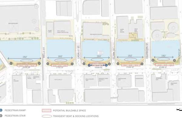
Back in 2009, SOM released its own plans for the riverwalk (Ross Barney Architects will lead the current project) that also envisoned new development east of State Street (PDF). A diagram of SOM's "arcade district"—the new plan's different themes between blocks is conceptually similar—from Franklin to State, shows how tight a squeeze commerce will have along the river.
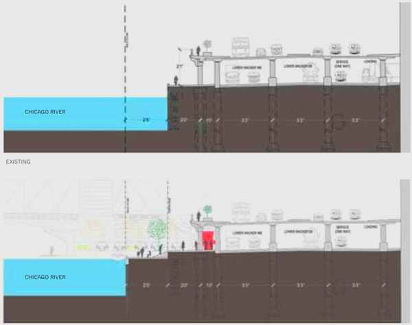
Here's a cutaway view:
The city's current plans only mention "The Marina" (State to Dearborn) as offering restaurant space; in SOM's plan, that riverwalk block offers only 2100 narrow square feet for vendor space (the SOM plan proposed a "Market District" from Michigan to Lake Shore Drive that offered much, much more room). It makes me wonder if this is where the city could finally come to terms with food trucks, which people have been asking for since the previous administration, but has resulted in only one mobile food preparation license. The riverwalk will be a small space, but one that would benefit from a space-efficient form of commerce that food trucks could provide.
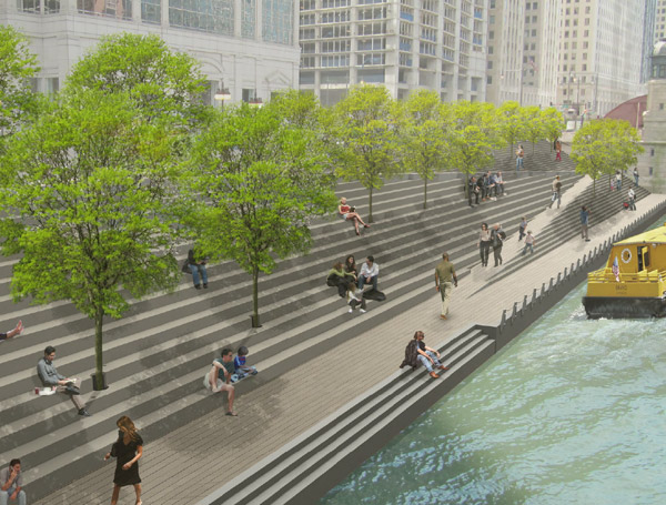
Here's what the current proposal looks like: