If you want to understand why Chicago became a great city — transportation hub of the continent, players with railroads and the nation’s freight handler, etc. — stand at the corner of Prospect Avenue, Touhy Avenue and Northwest Highway in downtown Park Ridge. Right in front of the Pickwick Theatre. In both directions, east and west, there’s a short rise leading up to the intersection. This is the watershed, now paved over, between the Great Lakes Basin and the Mississippi Valley. Raindrops falling to the east migrate into the Chicago River, then Lake Michigan. To the west, into the Des Plaines River, then the Illinois, then the Mississippi.
Unlike Detroit, Buffalo, or Cleveland, Chicago is not entirely a Great Lakes city. There are portions of the Northwest, West, and Southwest sides that lie outside their basin. But because Chicago lies astride the divide between North America’s most important water routes, it’s been a valuable transportation link ever since the time of the Native Americans and the French voyageurs, when the canoe was the fastest way to get around the continent. Chicago was a convenient way station not only because the Chicago and Des Plaines rivers are so close together, but because they were so easy to travel between. On the southwest side, a slough called Mud Lake often overflowed, allowing canoeists to simply paddle between two rivers, rather than carrying their cargo and vessels. The same was sometimes true on the Northwest Side. To control that route, Natives built a village near what is now Six Corners, which is why that neighborhood is named Portage Park.
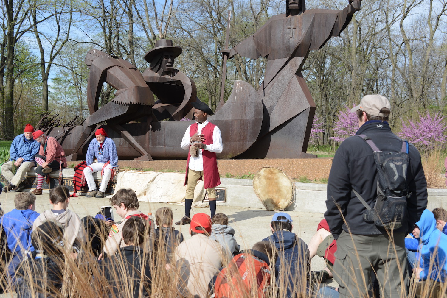
“The Chicago Portage is one of the most important, and neglected, places in the early history of the United States,” wrote Benjamin Sells in his 2021 book, A History of the Chicago Portage: The Crossroads That Made Chicago and Helped Make America. “Its significance began in prehistory as a place of habitation by the earliest Native Americans in the Midwest, and it became part of a major trade route for North American tribes. It was heavily used during the fur trade, was a focal point for the missionary and imperialistic dreams of French and British during the seventeenth and eighteenth centuries, and was a military concern for the British during the American Revolution. It was a gateway for settler expansion westward, and it served as a template for some of the most significant waterways created in the nineteenth and twentieth centuries. The Chicago Portage gave the city of Chicago its name, and was its original impetus for success.”
Marquette and Joliet first crossed the Chicago Portage in 1673, on a journey from the Mississippi River to Quebec, guided there by the Kaskaskia. Afterwards, Joliet wrote excitedly that a short canal would make it possible to paddle from Canada to Florida. The Illinois & Michigan finally opened in 1848, allowing water traffic to bypass the portage. The canal, railroads, and the Stevenson Expressway all follow the old portage route.
The Great Lakes-Mississippi watershed no longer plays a role in transportation, but it still exists, as a geographic feature and as a line on a map. I resolved to follow it through the Northwest side and the Northwest suburbs, to walk the once-significant divide that made Chicago great. It’s hard to tell, now, that you’re in such an important place.
From downtown Park Ridge, the watershed heads south, along a street that’s known as Ozanam on the Chicago side, and Canfield on the suburban side. Given Midwesterners’ predilection for straight, ruled boundaries, this is a rare border that follows a natural feature. I ask a passerby exactly which city I’m in. It’s hard to tell the difference, since I see the same mix of bungalows and McMansions on both sides of the street.
“This is Chicago,” she says, pointing east. “That’s Park Ridge. It’s that close. The Edison Park train station is right over there.”
Edison Park is to Chicago what the Northwest Territories are to Canada: a remote possession bordering a foreign land. When I am forced to cross Ozanam to avoid a ComEd truck blocking the sidewalk, I don’t just step from city to suburb, but from the Great Lakes to the Mississippi.
(Note: all the street names out here begin with “O,” since it’s the 15th letter of the alphabet, and this is 15 miles west of the city limits. Antoine Frederic Ozanam was a French historian and literary scholar who helped found the St. Vincent de Paul Society. Evidently, city planners just opened an encyclopedia to “O.”)
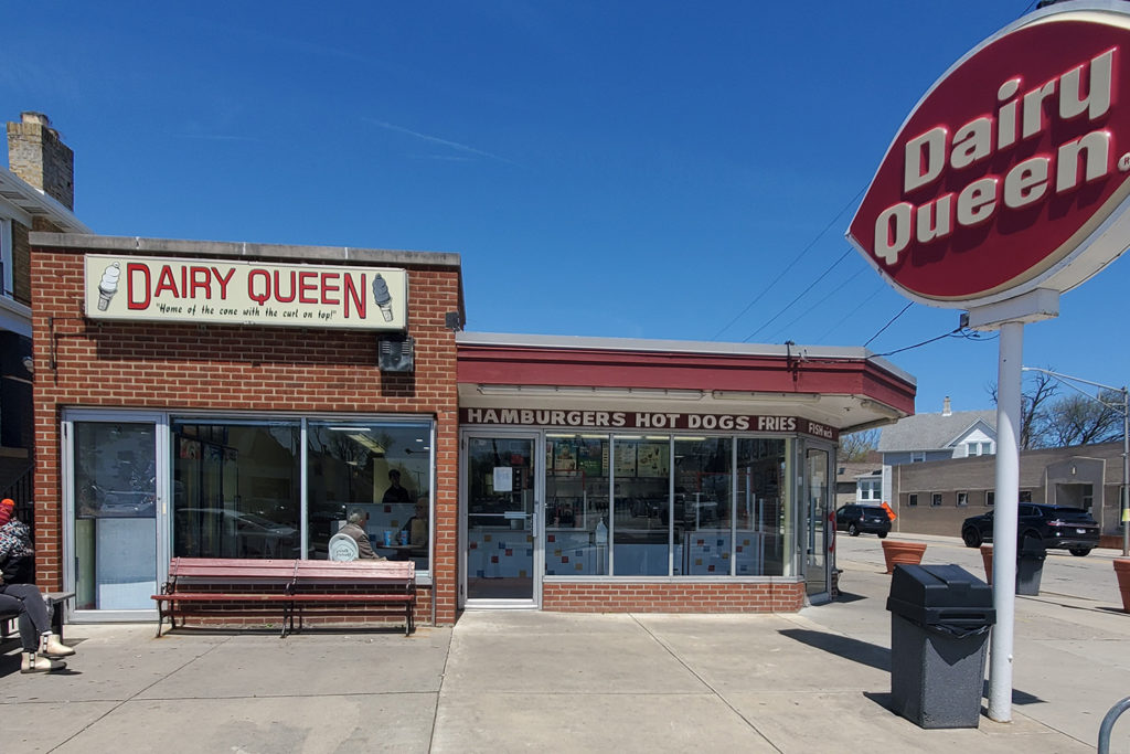
At Ozanam and Devon, the watershed passes an old-fashioned Dairy Queen (“Home of the cone with the curl on top!”), which is in the Mississippi Valley. South of Talcott Avenue, it jukes east, through a neighborhood suburban in all but address: two-story brick houses stand on quiet, winding streets, laid out in defiance of the Chicago grid. Basketball hoops rise in driveways, American flags fly from porches, planted in yards are “STOCK ROCKS” signs, in praise of Frederick Stock Elementary School, 7501 W. Birchwood Ave.
The watershed crosses the Kennedy Expressway, just east of Oriole Park, then crosses into another suburb: Harwood Heights, which only became a suburb because Chicago refused to annex it in 1947. It certainly looks the part of a Northwest Side neighborhood, with more bungalows than the Bungalow Belt, many displaying Polish eagles in their windows. (Nearly 20 percent of Harwood Heightsians were born in Poland, the second-highest percent in the U.S.) At the corner of Oketo and Carmen, I see a small rise leading up to the intersection, rare physical evidence of the watershed. (Note: according to the book Streetwise Chicago, “Arkaketoh was the chief of the Otoe Indians and the namesake of Oketo, Kansas.”)
At Lawrence Avenue, Harwood Heights gives way to Norridge. The watershed passes through Norridge Park, and leads me to the Norridge Manor strip mall. I’ve walked four miles, so I sit down for lunch in the ABC Bakery & Deli — a Serbian restaurant where I’m the only diner who doesn’t speak Serbo-Croatian. From the menu of peasant dishes, the doughty cook recommends the fish soup, then urges more food on me: “You want some bread? It’s homemade.”
The slices are thick and hearty, just what I need to keep walking to my next stop: the Harlem-Irving Plaza, located just inside the Great Lakes Basin. I have always felt that traveling west on Belmont, or Addison, or Irving, is like traveling backward through Chicago history, a decade at a time. Perhaps that’s why the HIP is still a thriving mall, with an Express, a Hobby Lobby, a Victoria’s Secret and a DSW. The surrounding neighborhood still belongs to the mall era. Right across the street is Rolling Stones Records, which is the coolest music store in Chicago not because of its voluminous stock of CDs, but because it is located directly astride the Great Lakes-Mississippi watershed!
After five miles of walking, my quadriceps are the consistency of Quikrete, so I unlock a Lyft e-bike. It makes the bungalows go by faster. The route takes me east through Dunning, then back across Harlem Avenue into another suburb, Elmwood Park. At the corner of Harlem and Wellington is a three-story apartment building with those groovy exposed stone accents that were so popular in the 1960s, and are such a common feature of Northwest Side architecture.
In Montclare, which has some old Victorian houses which are considerably fancier than bungalows, the watershed skirts Rutherford Sayre Park, with its Prairie style fieldhouse, and the Mars/Wrigley plant. On Oak Park Avenue, the brown honorary street sign is “Milky Way.” Clev-er. On Armitage Avenue, the air smells like a Three Musketeers bar, broken in half.
South of North Avenue, the street signs look foreign again.
“Am I in Oak Park?” I shout to a landscaper. (The fact that I see a landscaper should have answered that question.)
Yes, he tells me. I’m in Oak Park. My fifth suburb of the day. I’m not there long. At Austin and Augusta, the watershed turns abruptly east. It runs along Iowa Avenue, through the Austin neighborhood, past blocks and blocks of three-flats with lawns too small to be landscaped, until it turns sharply south, at a railroad right-of-way just east of Kilpatrick Avenue. It runs along those tracks all the way to 67th Street, just north of Ford City Mall — a ten-mile-long berm. That’s past the Chicago Portage National Historic Site, between the Des Plaines River and the Chicago Sanitary and Ship Canal in Lyons. This is as far as I’ll follow the watershed. Downtown, I lock up the bike near another watershed, the one between the Chicago River and Lake Michigan. It runs along State Street. (Further north, it runs, naturally, along Ridge Boulevard.) Chicago is a place where many waters meet.