Via Emily Badger's post "Living in Some Parts of Chicago Can Take More Than a Decade Off Your Life," the Joint Center on Political and Economic Studies has a new paper on neighborhood poverty and health in Chicago. It covers some familiar ground in regards to food deserts, poverty, and life expectancy, some of which may be familiar, and that Badger handles at length. But its maps additionally piqued my interest. One of the arguments of the paper is that access to chain and large independent grocers (as opposed to corner markets) remains statistically significant when it comes to premature mortality:
Controlling for poverty, education, age, race, and unemployment, the relationship between premature mortality and drug store access or fast food access lost statistical significance. Access to chain supermarkets, however, remained significant. This suggests that higher access to chain supermarkets in Cook County is associated with a decreased risk of premature mortality. Access to chain supermarkets or large independent grocery stores is also associated with a decrease in premature mortality, independent of other social factors.
It's a significant conclusion: even controlling for poverty, access to good food options effects premature mortality. And there are interesting differences in the geography of poverty and food access in Chicago. For instance, here are two maps of poverty in Chicago. On the left is census tracts by percent of population below 150 percent of the poverty threshold (dark red is 75-100 percent); on the right is the number of census years in poverty (dark red means the tract was impoverished in each census from 1970-2009).
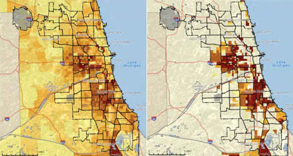
As you can tell, there are distinct patterns, with the highest poverty being concentrated in areas on the central west and south-southwest sides. Now, here are maps of life expectancy, on the left (dark red is 61-70, pale yellow is 88-95); and access to chain grocery stores on the right (dark red is highest access).
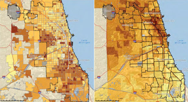
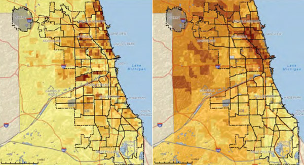
What's interesting to me about this map is that there's an overlap, on the far south side, of moderately high but not extreme poverty, and low life expectancy, that follows grocery-store access. Poverty in Chicago is not a neat north-south divide, but grocery-store access is much closer to that strict geographical difference. And part of the reason is density. Here's population density (left) next to grocery-store access (right):
Badger writes: "the patterns on these maps reveal that numerous forces are all intersecting in the same parts of the city: Neighborhoods with high concentrations of poverty are also the neighborhoods with the lowest educational attainment and the least access to pharmacies and food, and they’re also the neighborhoods where the city’s minorities tend to be segregated, and where the health outcomes tend to be the worst."
This is true; there are correlations among poverty, educational attainment, and food access. Not to mention homicide rates, as Steve Bogira wrote recently, and a multitude of other factors that Robert Sampson covers in Great American City: Chicago and the Enduring Neighborhood Effect:
Whether the measure is homicide, low birth weight, infant mortality, teen pregnancy, physical abuse, or accidental injury, there is compelling evidence pointing to geographic "hot spots" of compromised health…. At first blush, what could be more different than a woman giving birth to a baby weighing less than 2,500 grams and the murder of another human being, typically by a young male? Yet homicide is highly concentrated in the same communities [in Chicago] scoring low on infant health, with a clustering or corridor of compromised wellbeing on the Near South Side (e.g. the Grand Boulevard and Washington Park communities of our walk earlier), Far South Side (e.g. Riverdale, West Pullman, Roseland), and West Side (e.g. North Lawndale, West Garfield Park, and, to their south, Austin).
What's interesting to me about the maps above is that they seem to add another factor (food and drug access) to a specific problem (expected life span), something the authors found in their research. Poverty and segregation are obviously still factors, but they also manifest in subtly different ways across the geography of the city.