I’m always hard-pressed to explain where in Chicago I live. You’d think it would be easy, given Chicago’s well-defined neighborhood and community areas. But depending on where you live, it’s not always so easy.
For example: if you go by Chicago’s "Community Areas," as defined by my alma mater, I live in West Town, on the border of Humboldt Park, since I’m north of Grand between Western and California. (Looking at that map, I also notice that if you live at Sacramento and Division, practically in the embrace of the park itself, you still live in West Town.) If you go by the newer, semi-official Chicago neighborhood map, I also live in West Town. But according to the Department of Tourism, I live in Humboldt Park. By the zip code map in the office, I live in the Mid-West (60612). Don’t even get me started on "West Bucktown" and other realtor merriment.
Basically I live in West Town. But West Town is not a particularly useful designation, in part because it’s both a neighborhood and a community area. Even as a neighborhood it’s huge, running from California east to the Kennedy. So what sort of neighborhood is it, other than "that place north of the Ike that’s not Humboldt Park, Ukrainian Village, or Wicker Park"?
That’s the dilemma that faced Yale assistant professor Bill Rankin, proprietor of Radical Cartography. His solution is to create a census-based "dot map," an old but infrequently used form of cartography. His award-winning dot-map of Chicago makes a great companion to the other maps of the city, because you can see how neighborhoods break down by race. Let’s let him explain (h/t @nocoastoffense):
As Rankin points out, solid-color maps "visually reinforce political ideals… of ethnic homogeneity." And Chicago is definitely homogenous, but not always by neighborhood. West Town is homogenous, but only in areas within the neighborhood/community area:
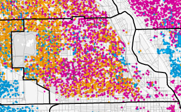
I live in the southwest corner of West Town: sort of Humboldt Park, sort of Ukrainian Village, sort of "West Town." It’s not the most diverse part of Chicago; that would be the northeast side along the lake, from Uptown north through Edgewater and Rogers Park, as you can see on Rankin’s big map. Rogers Park along Devon is also really diverse. By contrast, here’s Rankin’s map of the Bay Area, which is also segregated, but it’s more of a gradient. And despite Chicago’s reputation as the most segregated city in the country, there are no parts of the Bay Area that are as diverse as the far north-east side.