If you browse real estate listings, you may have noticed a thing called Walk Score, a software algorithm that judges how walkable an address, neighborhood, or city is based on various data. It's not just for casual users; even planners have picked up on it:
Walk Score has also been embraced by the planning community, not simply for its ease of use, but because the single number it provides is easy to communicate. In Phoenix, the city used Walk Score, along with housing and employment data, to help plan proposed light rail stations. Harriet Tregoning, Director of the Office of Planning in Washington, D.C., says Walk Score provides a handy metric that is otherwise often missing from many discussions.
As with any single-number measurement of an abstract concept, it's worth taking with a grain of salt, but it also highlights a public-planning issue and brings it to a broader audience. The sensible next step, of course, is how bikeable a city is, and Walk Score just introduced Bike Score, in beta, based on hilliness, bike-lane coverage, the robustness of the bike-commuter community, and destinations ("network distances to a diverse set of amenities and calculates connectivity metrics such as average block length and intersection density"). Chicago comes in 10th, just behind Tuscon, and 12 points behind first-place Minneapolis. The calculation of commuters is interesting:
We decided to add a fourth component to Bike Score, bike commuting mode share from the US Census, to try to capture some of this social component. We create a 1 km moving window over the census tract level data and normalize bicycle mode share from 0 – 10% to a score between 0 – 100.
The result is a series of heat maps that make for a nice at-a-glance comparison of how different cities approach biking. For instance, here's Minneapolis's bike-commuter map versus Chicago's:
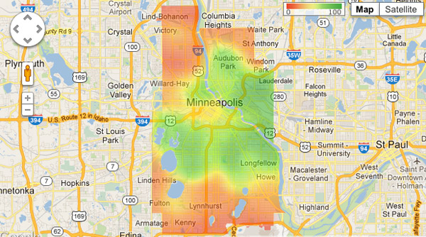
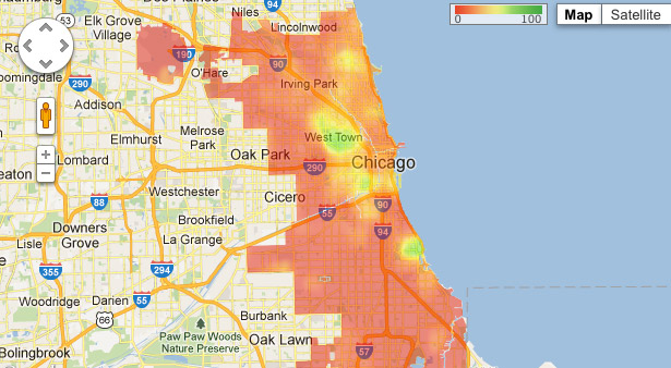
You can start to see where you have to be careful using single-number metrics. Chicago's at something of a disadvantage because it's much, much bigger than Minneapolis, 234 square miles to 58. Closer to the central business district, where lots of people work, the city fares a bit better.
Or San Francisco's bike lanes (the city came in second behind Minneapolis) with Chicago:
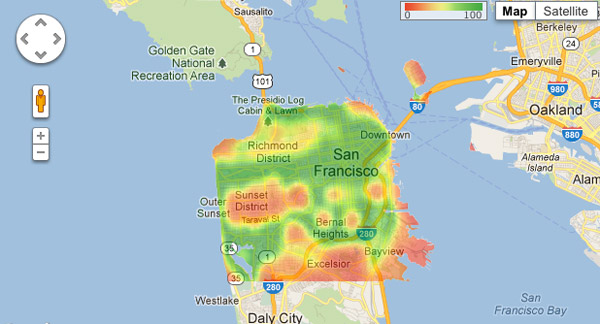
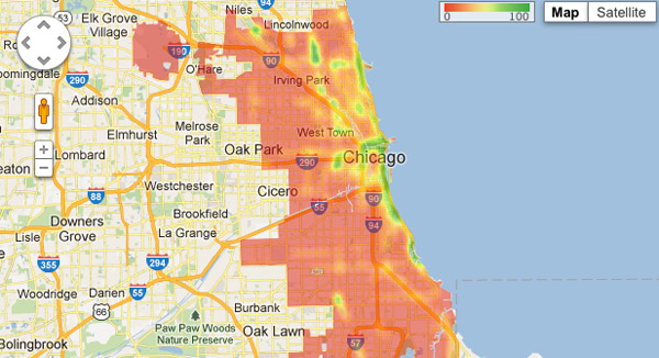
Again, take it with a grain of salt. San Francisco is small (a mere 47 square miles of land). And a place can be relatively bikeable without bike lanes; most of my commute is along Grand, which doesn't have much bike-lane coverage but is so wide that I'd rather bike it than, say, the bike lane on Milwaukee between Ashland/Division and Damen/North or the bike lane along Illinois downtown. But as computer-generated generalizations go, Bike Score is handy.