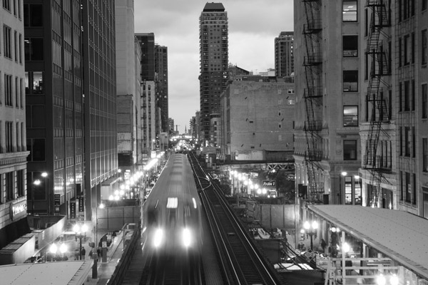
What defines Chicago? Physically, I mean. It's a vast, flat expanse of land, and if you were designing it from scratch, SimCity style, it could look like anything: an ice cream cone, a Jackson Pollock painting. But over time it's been the Loop that defines the city's downtown, and makes the city unique.
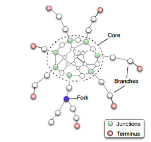
Or maybe not. A new paper, "A Long-Time Limit for World Subway Networks," posits that big-city subway systems around the world are essentially the same, or at least converging on "a shape which shares similar generic features despite their geographic and economic diff erences. This limiting shape is made of a core with branches radiating from it." As Brandon Keim puts it, "in the absence of top-down central planning, their movement over decades toward a common mathematical space may hint at universal principles of human self-organization."
Basically, it looks like this; cut it in half, and you've basically got the El:
A governmental-social unit organized by concentric circles… converging on an ideal form… where have I seen that before…

Sorry, wrong one.
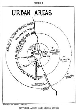
Right. That's the "concentric zone" model of University of Chicago profs Ernest Burgess and Robert Park from their 1925 The City, one of the foundational works of modern sociology (though it obviously borrows from von Thunen's 1826 regional land use model). It's an old model, dating back to the beginnings of urban sociology, and reflects the development of cities from transportation hubs: train stations and ports at the city center. It's still useful:
While some sociological aspects of the concentric zone theory like residential succession no longer apply to Chicago as they did in the 1920s, certain elements of the model are still visible in the city’s landscape today. In the map above, which shows the footprint of every building in Chicago color-coded by the period in which the structure was built, a pattern of concentric zones is quite strikingly apparent.
The model of Burgess and Park has been challenged, in large part because forms of transportation rapidly changed after 1925, notably the embrace of the car. One challenge came from later University of Chicago sociologists, Chauncy Harris and Edward Ullman, who developed the multiple-nuclei model of urban structure:
The number of distinct nuclei occuring within a city is likely to be a function of city size and recentness of development. Auto-oriented cities, which often have a distinct horizontal as opposed to a vertical appearance, include industrial parks, regional shopping centers, and suburbs layered by age of residents, income, and housing value. Rampant urban sprawl is likely to be reflected in a mixed pattern of industrial, commercial, and residential areas in peripheral locations. Geographer Peirce Lewis describes this sprawling urban landscape as the galactic metropolis because the nucleations resemble a galaxy of stars and planets. Some of those nucleations become cities in the suburbs, what have become edge cities. These edge cities are, in effect, the CBDs [central business districts] of newly emerging urban centers scattered through the suburban ring surrounding older central cities.
This is where I get skeptical that subways converging towards a "common mathematical space may hint at universal principles of human self-organization." The subway systems the authors study were built within a relatively narrow band: 1863 (London) to 1995 (Shanghai). But they're all also very old cities. Shanghai has a dense central business district, dating back to its long history as a port town; Moscow's rings radiate out from the Kremlin and Red Square, following old fortifications; Beijing grew out from a model of urbanism that way predates Burgess and Park:
Many researchers reached consensus on urban morphology of the Old Beijing from physical composition. It is agreed that the Old Beijing was laid out exactly according to the concept of the Chinese utopia capital city in the book Kao Gong Ji, Notes on Works, written more than 2,000 years ago. The ideal city form is ‘a walled square city of nine by nine li (4.5 kilometers) with nine north/south main streets and east/west main avenues, three gates on each side, the ancestral temple on the left and an altar on the right of the palace, municipal administration buildings in front of the palace and a marketplace behind it’ (Fu, 1998; Liu, 1986).
So: who cares? If it's just a neat little mathematical model, what's its relevance? It's relevant when the model becomes prescriptive, as the authors of "World Subway Networks" write:
In the case of Beijing, Seoul and Shanghai, it seems that their relative 'youth' is why they have not yet reached their long time limit.
Translation: since the subways were started after 1971, they haven't fully converged on that ideal "core and branch" shape and ratio.
We can also note here that the least expensive way for the almost mature networks to reach a better well-balanced long time limit is by constructing the minimum number of stations
and lines. This then suggests that Seoul and Shanghai need to increase their core density… (by adding inter-branches links for example) and Moscow needs to increase its core.
But Beijing doesn't necessarily want to reach the ideal core-and-branch shape, if a paper by Beijing Normal researchers (which relies heavily on Burgess, Park, Harris, and Ullman) is any indication:
The results have shown that the spatial pattern of the Beijing metropolitan region has been influenced by the ring-road system, historical context and the planned activities. Because of the concentric ring-roads, the land use pattern and urban functions of Beijing has a general zonal structure that appears to conform to the concentric zone theory. However, this apparently concentric zonal pattern is not consistent with the differentiation of social and economic classes that underlines the classic theory.
I.e. it's an old city that's developed concentrically because of history and urban planning, beginning with its ideal walled city hundreds of years ago. It's not necessarily a great model for the 21st century:
Although the regional government wants to diffuse the population and functions of central city, the edge cities have not attracted too much population from the central city because the high-quality elementary and high schools, hospitals and hotels concentrate in the city center…. Hence, the infrastructure of the edge cities should be complemented in order to attract more population from the central city. The immigration of population from the central city should be accompanied with the high-quality elementary and high schools, hospitals and hotels…. With the construction of edge cities, the traffic congestion will be improved. Compared with the classic concentric zone theory, high-income people have not moved to the suburbs because the time spending on the way. The concentric analysis can be beneficial to understand the spatial structure of Beijing and to improve the planning activity. The comparison of Beijing with Chicago will shed light on the understanding of their differences.
Hey, that's us.
In short, Beijing is stuck in Park and Burgess's concentric zones, and wants to move towards Harris and Ullman's multiple-nuclei model. At the very least, it's neat to see these comparatively dated theories of urbanization at the forefront of 21st century development. But the Beijing subway system may be following a multiple-nuclei model:
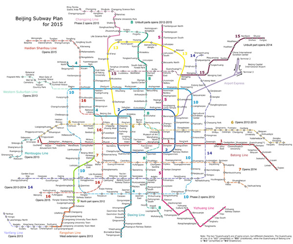
The solid lines are existing routes; the dotted lines are in progress (a bigger version is here). What's being built looks to me more like a lattice, or a core-lattice hybrid. Rather than connecting up to the center core, the new lines mostly connect periphery to periphery. If the city truly wants to address its crippling traffic problem through the "immigration of population from the central city," it's a sensible choice: a core-branch structure will inevitably make the central city more convenient for public-transit riders, increasing commercial and/or residential density, and thus car traffic density. Reducing commutes from edge city to edge city might sound like a disaster in a city facing population declines, like Chicago, but it might work for a city that's reached excess density. Beijing has added 17 million people in the past 60 years, six million in the past decade.
Take any "natural model" or an "ideal form" for cities with a grain of salt—the authors, to their credit, are—not least because of their recent history in the Chicago school of sociology, where people have tried to "make urbanism a quantitative science, and understand with data and numbers the construction of a city" for almost a century.
Images: Wookipedia, Wikipedia, -Tripp- (CC by 2.0)