* I do not know who runs "Monkeying Around with Chicago Data," but whoever does it is underselling his talents. This post on segregation in Chicago, far from monkeying around, is really great, and suggests what the future of segregation (and desegregation) will look like:
Tracts which were previously almost uniformly African-American are becoming more integrated on average (more lie below the line). Some of the outliers here are tracts in or around the Loop which exploded in population over the last decade. The others include tracts in increasingly-upscale neighborhoods on the South Side lakefront (Douglas, Kenwood), gentrifying parts of the West Side (East Garfield Park, Humboldt Park), and middle-class areas where the Latino population is increasing.
So, the news is mostly good. Black residents seem to be more welcome in neighborhoods where they were previously excluded (remember, we're comparing to the relatively recent past when the first black residents were regularly greeted with panic and/or violence). And non-black residents seem to be slightly more willing to move into majority black neighborhoods. On the other hand, the vast majority of the outlier tracts are those where the fraction of black residents is decreasing. That makes sense in light of the widely-reported overall decrease in Chicago's black population, but it's striking nonetheless.
It's quite easy to use the law to increase segregation; we have made progress in stopping that. We've also made progress in using the law to combat private-sector policies that encourage segregation, such as the state's massive lawsuit against Wells Fargo. We don't, however, have good ideas for decreasing segregation beyond removing the barriers to segregation; or perhaps more accurately, we have ideas that show some promise but work slowly within a fairly narrow conceptual range. Which is inevitably slow; Nikole Hannah-Jones's remarkable piece for ProPublica is a good, in-depth introduction to the past and present of housing policy and segregation.
* This is cool:
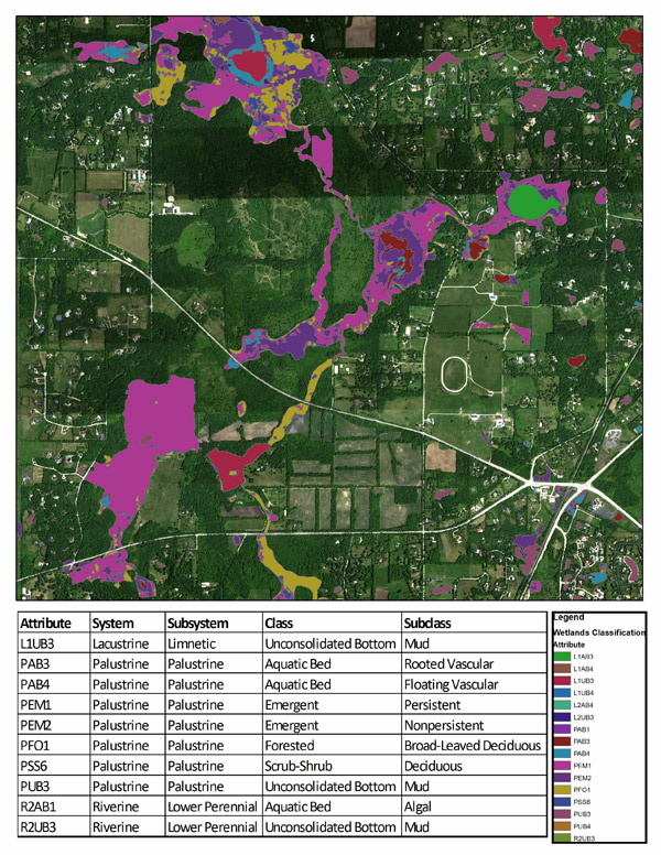
Over the past year, private contractors Merrick and Company, along with Galileo Group, Inc., have been flying a Cessna 172 Skyhawk at 5,500 feet in a lawn mower-like pattern of east and west parallel flight lines over all of Cook County. Installed in the fuselage of this small airplane is a hyperspectral imaging system which leaves just enough room for a pilot and a sensor operator. This hyperspectral sensor is not your average camera: about the size of a bread box and weighing about 80 pounds, this ultra-high-tech device is integrated with a high precision Global Positioning System (GPS) and Inertial Measurement Unit.
[snip]
Once the aerial imagery is collected, a highly trained remote-sensing scientist processes the data by removing distortion and calculating the latitude and longitude of each pixel. Later, this scientist travels by foot to areas already known to be wetlands and uses a handheld computer to take ground measurements. These are then overlain on the aerial imagery and used to extract a “signature” for each of the different wetland types. The scientist creates a spectral library of these signatures and is then able to identify additional wetlands based on the collection of traits found within square-meter pixels. In this way, the spectral library can be used to identify and classify all wetlands found in Cook County.
For instance, the spectrum indicated by dark purple PEM2 indicades nonpersistent, emergent palustrine: "Wetlands in this Subclass are dominated by plants which fall to the surface of the substrate or below the surface of the water at the end of the growing season so that, at certain seasons of the year, there is no obvious sign of emergent vegetation."