Thomas Jefferson wrote the Declaration of Independence, founded the University of Virginia, and invented a portable desk with a hinged writing board.
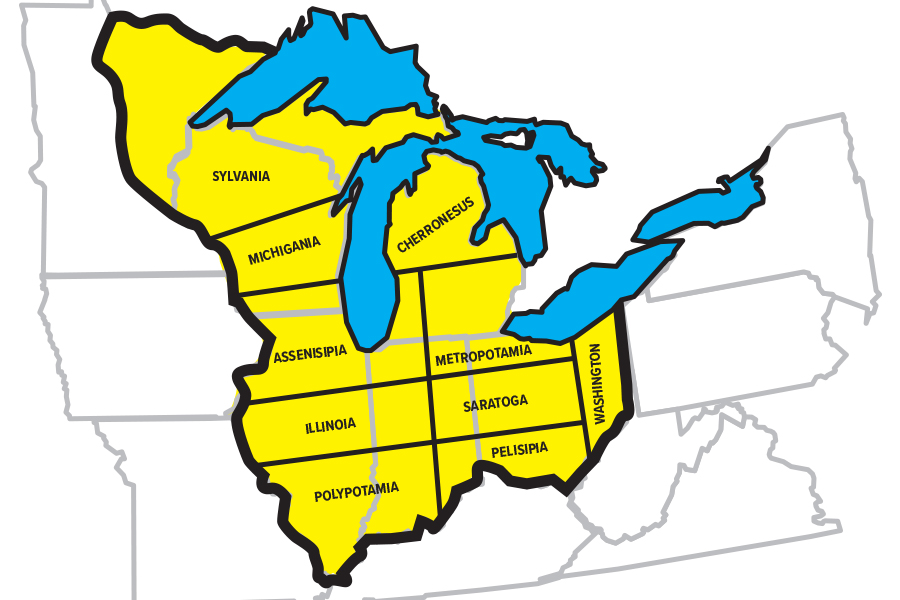
He also drew a map of the Midwest that, as it turned out, was better than the one the actual mapmakers came up with. If Jefferson had gotten his way, we would now be living in Chicago, Assenisipia. Instead of sharing a state with far-away Bloomington, Peoria, and Effingham, we would be grouped in with Kenosha, Wisconsin, Michigan City, Indiana, and New Buffalo, Michigan — places most of us actually visit.
After the American Revolution, the United States claimed the land north of the Ohio River between the Allegheny Mountains and the Mississippi River. Jefferson was put in charge of a committee whose task was to draw up a “Plan for Government of the Western Territory.” They drew up a map dividing the nation’s new lands into ten states — and I have to say, they make more sense than the ones we have now.
(Jefferson’s map is currently on display at the Newberry Library’s exhibit What Is the Midwest? In our sketch of the map, below, the black lines indicate his vision, and the gray ones what we have now.)
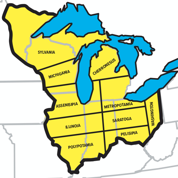
Assenisipia, which drew its name from the Native American term “Aws-uni-sipiau,” meaning “we challenge to own and possess,” would have been bounded on the west by the Mississippi River; on the east by a line drawn from the Falls of the Ohio, at Louisville; on the north by the 43rd parallel; and on the south by the 41st parallel. Jefferson, whose education at William & Mary included lessons in geometry, already appeared to be embracing the Euclidean angles that would later define Midwestern townships, counties, and roads.
Jefferson had never visited the Midwest, and never would, but his state of Assenisipia was a nearly perfect creation for our modern interests. It was roughly coterminous with what would become the Chicago-Naperville-Elgin IL-IN-WI Metropolitan Statistical Area — or the Census Bureau’s designation of what we call “Chicagoland.” An area clustered around the southern end of Lake Michigan, Assensipia would have been a state with common accents, common economic interests, and maybe a common political outlook.
Jefferson’s map divided Illinois into three states. Anyone familiar with our history, culture, and geography would agree this was sensible. “Illinoia” would have included the farm counties of Central Illinois, as well as western Indiana. “Polypotamia” would have taken Little Egypt, southern Indiana, and western Kentucky, communities with shared Southern roots that get along with each other far better than Southern Illinois does with Chicago.
Slicing the long, ungainly state of Illinois into three layers would have spared us the Chicago–Downstate conflict that has recently led rural legislators to propose separating Illinois’s hinterlands from its great metropolis. The map would have had the same result in Michigan. Instead of becoming a distant colony of Detroit, the Upper Peninsula would have belonged to the state of “Sylvania,” along with modern-day northern Wisconsin and northern Minnesota, with whom it shares interests in mining, logging, drinking, snowmobiling, and the Green Bay Packers.
For various political reasons, Jefferson’s map never became a reality. Ten states was too many for the inhabitants of the original eastern colonies, who didn’t want to dilute their power by giving the Midwest 20 senators. Also, every territory wanted a Great Lakes port. Illinois successfully lobbied to move its border north 55 miles, from a line beginning at the southern end of Lake Michigan, so it could take in the little trading post on the Chicago River. Indiana wanted a slice, as well. Michigan was granted the Upper Peninsula as compensation for losing Toledo in a dispute with Ohio.
As he drew lines on a map, there’s no way Jefferson could have known how his yet-unsettled states would turn out. He was simply trying to design a framework for the new territory, and its eventual incorporation into the union. As Jefferson’s most thorough biographer, Dumas Malone, wrote, “he dreamed of … an expanding Union of self-governing commonwealths, joined as a group of peers.”
The most significant way in which Jefferson’s map differed from the final result is that he designed states with east-west orientations, which matched the flow of internal migration. In Illinois, we ended up with a north-south orientation, which yoked together Yankee, Midland, and Southern settlers whose descendants are still squabbling to this day.
So we can’t exactly give Jefferson credit for being a visionary. But we can give him credit for trying to apply logic to a process that was ultimately determined by politics and parochial interests.