Over the past year or so, I have visited all 77 of Chicago’s community areas by bus, train, bicycle, or gym shoe. Much has been written, much has been broadcast, about how Chicagoans talk, or how Chicagoans like their pizza, or what Chicagoans like to drink, or how Chicago’s woke prosecutors have made the city as dystopically anarchic as Somalia, circa 1992, or what constitutes a real Italian beef sandwich. Yet Chicago is too vast and contains too many multitudes for such generalizations. It’s been said that Chicago is a city of neighborhoods. Having traveled from Rogers Park to Mount Greenwood, from Edison Park to Hegewisch, and all the way down Ogden Avenue, until it turns into Cicero, I prefer to think of it as a city of sub-cities, each with distinct foodways, ethnic makeups, political outlooks, and bars you probably shouldn’t go into if you don’t look like you’re from around there. I’ve identified 15, and will proceed to make generalizations about them, rather than Chicago as a whole. (There is one hard and fast rule I can offer about life in Chicago: Don’t ride a bicycle on 130th Street. There’s no bike lane, and you may get sideswiped by a truck under the viaduct near the Ford plant.)
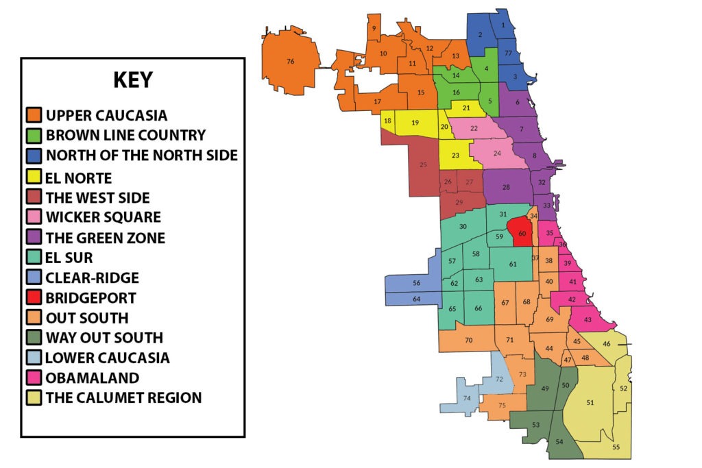
Upper Caucasia
O’Hare, Edison Park, Norwood Park, Dunning, Forest Glen, North Park, Jefferson Park, Portage Park
The Far Northwest Side is, mostly, indistinguishable from the surrounding suburbs. Get off the UP-NW Metra at Norwood Park, walk the mile around Circle Drive, and you might think you’d ridden all the way to Woodstock. Every pre-war home is adorned with an American flag, a St. Patrick High School placard, or both. That’s because the neighborhood’s city workers would live in the suburbs if they could. Walk the street dividing Edison Park and Park Ridge (Ozanam in the city, Canfield in the suburbs), and you’ll see the same mix of McMansions and bungalows on each side. The streets are even off the Chicago grid, angling and ovalling in suburb-like confusion. The Forest Glen community area, which includes Edgebrook and Sauganash, is 74 percent white. (Edison Park is 82 percent.) Upper Caucasia also boasts the city’s grooviest collection of two flats and apartment buildings with mid-century stone accents.
North of the North Side
West Ridge, Rogers Park, Edgewater, Uptown
Uptown, Edgewater, Rogers Park and West Ridge are more diverse and less prosperous than the neighborhoods to the south. There is no ethnic majority here. Uptown has a more uptown feel than it did 20 years ago now that the old men’s hotels have been converted to luxury micro-dwellings, but there are still remnants of its hippie and hillbilly past, such as the apartment house owned by Jesus People USA and the $3-a-beer tavern Max’s Place. Rogers Park is a traditional entry-level neighborhood for immigrants: Sullivan High School’s students come from 35 countries and speak 38 languages. The most diverse census tract in the city is in West Ridge, bounded by Ridge Boulevard, Pratt Boulevard, Western Avenue, and Devon Avenue. Its population is 32 percent Asian, 24 percent Black, 23 percent Hispanic, and 21 percent White. All along Devon are houses of worship for most major religions: Christianity (Catholic, Protestant and Orthodox), Islam, Sikhism, Hinduism and Judaism.
Brown Line Country
Albany Park, Irving Park, Lincoln Square, North Center
The Brown Line is the bourgeoist of the ‘L’ system’s major routes, because it’s the only one that doesn’t pass through a poor neighborhood. After leaving the Loop, the Brown Line travels through Lincoln Park, then on to North Center, sometime home of U.S. Ambassador to Japan Rahm Emanuel, and Lincoln Square, which gives Andersonville a run for its money as Chicago twee-est shopping district: book stores, vinyl shops, a vintage toy store, fashion eye boutiques, and the Old Town School of Folk Music. (The Old Town School probably puts Lincoln Square on top.) The Brown Line ends at Kimball, in Albany Park, a grittier neighborhood with a socialist Latina alderwoman (Rossana Rodriguez Sanchez, who ended the 40-year Mell dynasty), and a good selection of Middle Eastern and Mexican restaurants.
El Norte
Hermosa, Avondale, Belmont Cragin, Montclare, Humboldt Park
After Puerto Ricans were forced out of Lincoln Park by rising rents in the 1970s, they moved inland to Wicker Park, Humboldt Park, and the neighborhoods along Milwaukee Avenue. This is where Latino political empowerment in Chicago began: The state’s first Latino legislator, Joe Berrios, and its first Latino congressman, Luis Guiterrez, are North Side Puerto Ricans. So is Miguel del Valle, the first Latino city clerk, an office that once belonged to the Poles. Much of this area is now represented by Ald. Carlos Ramirez Rosa, a democratic socialist elected by a coalition of Latinos and white hipsters, who also landed here as a result of gentrification: “You have young white progressives and longtime Latino immigrant families agreeing very broadly on things like rent control, the need to raise the minimum wage, the need to support public sector unions, and the rights of workers generally,” Rosa said. This is also the heart of the new Latino congressional district won by state Rep. Delia Ramirez.
Wicker Square
Wicker Park, Logan Square
During Chicago’s cultural and economic renaissance of the 1990s, Wicker Park was a birthplace of the city’s alternative music scene, which was second only to Seattle’s in that decade. The Double Door opened at North and Milwaukee avenues in 1994, just in time to book The Smashing Pumpkins. Nick Hornby’s novel High Fidelity was turned into an American movie set in a record store at the corner of Milwaukee and Honore, starring John Cusack, just the kind of guy who would move to Wicker Park from Evanston. (Local H’s Scott Lucas actually did move to Wicker Park, from Zion.) MTV’s The Real World tried to glom onto Wicker Park’s hipster cred, moving its hapless cast members into a building once occupied by Urbus Orbis. They were harassed mercilessly by real-life hipsters. Sharing that progressive Milwaukee Avenue vibe is Logan Square, which has nearly equal numbers of white and Latinos. Both communities gathered last year at the Illinois Centennial Memorial Column to protest the police shooting of 13-year-old Adam Toledo. They then marched to the home of Mayor Lori Lightfoot, who lives in the neighborhood, but is the type to drink at Emporium and eat at Lula Cafe.
The Green Zone
Lake View, Lincoln Park, Near North Side, Loop, Near South Side, Near West Side
From Wrigley Field on the north to the Field Museum and Soldier Field on the south, with Lincoln Park and the Loop in between, this is the Chicago the tourists see. People here have high incomes, high educational attainment, and low levels of connection to Chicago. The Near North Side, which includes the Gold Coast, leads the city in per capita household income, at $101,727. In some parts of the Loop, fewer than 20 percent of the residents were born in Illinois. “All the Big Ten grads, if they want to move to a big city, you move to Chicago,” says the owner of Sluggers, an Indiana University-themed bar on Clark Street. “The younger demographic tends to live their first couple years in Lake View and Lincoln Park.” The next step is the West Loop. The city’s fastest-growing neighborhood, it’s the new home of McDonald’s, Google, and 41-story apartment towers where studios rent for $1,590.
The West Side
Austin, West Garfield Park, East Garfield Park, North Lawndale
There’s a mural at the corner of Madison Street and Kostner Avenue, with the following statistics: 42 percent of West Garfield Park residents live in poverty, compared to 4 percent in Naperville. The median home value is $164,500, compared to $593,000 in Lincoln Park. West Garfield Park, East Garfield Park and North Lawndale are among Chicago’s six poorest neighborhoods. North Lawndale, once the heart of Jewish Chicago (“the Vest Side”), is now 87 percent Black, and has lost three-quarters of its population since 1960. The neighborhood has a lot of storefront churches with very long names — Anointed Emmanuel Deliverance Temple of Apostolic Faith — and a little light industry, such as metal finishers and sheet metal fabricators. North Lawndale is separated from Latino Little Village by the Burlington Northern railroad tracks, although Latinos have been moving north of the tracks. After Blacks and Latinos clashed during protest over the murder of George Floyd, both neighborhoods joined in a peace march under the banner “One Lawndale.”
Bridgeport
Bridgeport is a land unto itself, right in the middle of the city. Home to five mayors, it was for generations a white island on the South Side, its racial integrity defended by the Dan Ryan Expressway and the Daley family, which refused to protect Black residents who tried to integrate the neighborhood. Today, though, Asians have surpassed whites as Bridgeport’s largest ethnic group: The neighborhood is so close to Chinatown it’s becoming a second Chinatown. Political power is following. When Daley scion Patrick Thompson was forced to resign from the city council after he was convicted for lying to the feds about a bank loan, Mayor Lightfoot appointed Chinese-American Nicole Lee to replace him.
Obamaland
Douglas, Oakland, Kenwood, Hyde Park, Woodlawn, South Shore
From Bronzeville to South Shore, this is the cultural heart of the South Side. The Checkerboard Lounge, the city’s most storied blues club, operated on 43rd Street until 2003 (it moved to Hyde Park and operated at 52nd and Harper from 2003 until it closed in 2015). Bronzeville is now an art district, known for Gallery Guichard and Faie African Art Gallery. Kenwood was the home of President Obama, who bought a Georgian manse in a neighborhood where University of Chicago economists blew their Nobel Prize loot on big, historic houses. (He still votes there, even though he lives on Martha’s Vineyard.) Hyde Park is a college town embedded in a big city, with a gothic university quad, two of the world’s greatest bookstores — 57th Street and Seminary Co-op — and the greatest student-budget cafeteria, Valois. A U of C type once said “I’m not a Chicagoan, I’m a Hyde Parker.” We’re not going to make Hyde Park its own sub-city, though, because Hyde Parkers already have too much to be proud of. The new Obama Center, a monument to the 44th president, is going up in Woodlawn’s Jackson Park. Theaster Gates’s Stony Island Arts Bank contains a collection of books that belonged to Johnson Publishing, publisher of Ebony and Jet, and Frankie Knuckles’s vinyl collection.
Out South
Armour Square, Fuller Park, Grand Boulevard, Washington Park, Englewood, West Englewood, Greater Grand Crossing, Ashburn, Auburn Gresham, Chatham, Burnside, Avalon Park, Calumet Heights, Morgan Park, Washington Heights
Natalie Y. Moore, author of The South Side: A Portrait of American Segregation, grew up in Chatham, and calls her home “a magical place.” “In summertime Chi,” she wrote, “the aroma of barbecue wafts from backyard grills and smoky rib joints onto the Dan Ryan Expressway. Driving east on 79th Street toward Lake Michigan is a colorful trip: men sipping out of bottles on corners, vibrant businesses, bars, funeral homes, foreboding boarded-up structures, liquor stores, churches, Harold’s Chicken Shacks and sounds of house music dancing in the air.” You will find the best barbecue here, at Lem’s on 75th Street, or Uncle J’s on 47th (when they don’t run out of food). Chicago’s greatest rapper, Common, grew up on 87th Street. Englewood is one of Chicago’s most dangerous, depopulated neighborhoods, but Burnside, Chatham, and Morgan Park are full of quiet, stable, middle-class homes populated by schoolteachers, postal workers and other public servants.
El Sur
Lower West Side, South Lawndale, McKinley Park, New City, Brighton Park, Archer Heights, West Lawn, West Elsdon, Chicago Lawn, Gage Park
In the 1960s, when Poles and Bohemians began leaving South Lawndale for the suburbs, the president of the local chamber of commerce renamed the neighborhood Little Village, and recruited Mexican-Americans to replace the fleeing white ethnics. At the same time, Mexican-Americans were moving to Pilsen after their West Side neighborhood was destroyed to build the University of Illinois-Chicago. The Southwest Side is now dominated by Latinos, who were attracted to the area by low housing costs and proximity to blue collar jobs, such as meatpacking plants in Back of the Yards. Latinos have gradually been replacing whites in the state legislature and on the city council, many with the support of the new local boss, Congressman Chuy Garcia. There are still a few legacies of the old ethnic population: the Polish Highlanders of America clubhouse on Archer Avenue, and a shelf of Polish-language books at the Archer Heights library.
Clear-Ridge
Garfield Ridge, Clearing
Garfield Ridge and Clearing are twin neighborhoods west of Midway Airport, with their own newspaper, the Clear-Ridge Reporter. Planes zoom past the corner of 63rd Street and Central Avenue, less than 100 feet overhead. Although Latinos recently became the most numerous ethnic group in both communities, Garfield Ridge and Clearing still maintain much of the white ethnic character that once defined the Southwest Side. A laser eye treatment center advertises service in Spanish and Polish. Back the Blue American flags dangle above porches, and taverns display signs declaring “We Support Alderman Marty Quinn” — one of the South Side’s last two Machine aldermen, along with Ed Burke. Donald Trump won most of the precincts west of Narragansett Avenue. Will Clear-Ridge eventually become part of El Sud? Three-quarters of the students at John F. Kennedy High School are Latino, but this is as far west as city employees can go, which guarantees a continuing presence of conservative whites.
Lower Caucasia
Beverly, Mount Greenwood
Just like Upper Caucasia, Beverly and Mount Greenwood are populated by civic employees living as close to the city limits as they legally can. More than 10 percent of Mount Greenwood’s residents collect a paycheck from the fire department, police department, Streets and San, et. al., the highest in the city. Mount Greenwood is also Chicago’s Trumpiest neighborhood: The former president won some precincts by 40 points. In most of the city, Western Avenue is a utilitarian thoroughfare, but in Beverly, it’s a suburban high street, with gastropubs, a bookstore, and a vinyl shop. This is also the best place to hear a classic Chicago accent: Listen to the patrons at Wrong’s Tap, a sports bar, or McNally’s, a sports bar.
Way Out South
Roseland, Pullman, West Pullman, Riverdale
This is the most isolated corner of the city, beyond the reach of the ‘L’ system. The shopping strip along Michigan Avenue in Roseland was once a busy neighborhood downtown, anchored by Gatelys Peoples Store. Gatelys moved to Tinley Park in 1981. Most of the stores today are owned by immigrants peddling distressed jeans and sports jerseys. Old Fashioned Donuts — Chicago’s finest donut shop — has survived, though. Riverdale, which contains the Altgeld Gardens housing project, is the poorest community area, with a per capita household income of $11,857. The city continues even beyond the Gardens, to a tumbledown neighborhood south of the Calumet River that one resident called “the end of Chicago.”
Calumet Region
South Chicago, East Side, South Deering, Hegewisch
The Far Southeast Side was once the industrial heartland not just of Chicago, but the entire nation, nicknamed “the Ruhr of America.” U.S. Steel South Works, in South Chicago, employed 20,000 workers, and was a port of call for ships carrying iron ore from Michigan’s Upper Peninsula and Minnesota’s Iron Range. All that remains of U.S. Steel is the ore wall, which the park district has transformed into a climbing range. All attempts to turn the site into a new lakefront neighborhood have failed, due to lingering pollution. The East Side, so named because it’s east of the Calumet River, was the site of a Republic Steel plant that closed in the early 2000s. The neighborhood is 80 percent Latino, but Mexicans have been living there since the 1920s, when they arrived to work in the steel mills. Our Lady of Guadalupe on 91st Street in South Chicago — OLG — is the city’s oldest Spanish-speaking parish. Hegewisch, at Chicago’s southeastern corner, has a small town, rural feel. It contains Chicago’s only state park, the William W. Powers State Recreation Area, alongside Wolf Lake — and its only trailer park.